 INSTITUTE FOR NATURAL RESOURCES
Oregon Explorer Top Menu
You are here
Lakes Basin
Lakes Basin
LEGEND

 |
 |
 |
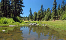
Salmon and Trout in the Deschutes BasinThe Deschutes River is world famous for its trout fisheries including native populations of Columbia River redband trout also called "redsides," and steelhead. |
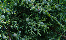
Juniper Removal and Upland Restoration in OregonIn Central and Eastern Oregon, the issue of juniper encroachment has become a main cause of many ecological imbalances. |
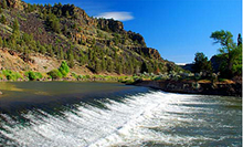
Deschutes Basin Development and GroundwaterAgriculture, ranching, and tourism form the backbone of the area's economy, and these economic drivers all require access to water for irrigation and recreation. |
Explore Related: |
Explore Related: |
Explore Related: |
About This Place
The development of the site formerly known as the "Deschutes Basin Explorer" resulted from collaboration among:
OSU Libraries and Press: OSU Libraries and Press engages with the OSU community and the people of Oregon in their pursuit of knowledge. The OSULP partnership with the Institute for Natural Resources supports delivery of information and services related to the protection and management of Oregon's vitally important natural resources through the Oregon Explorer natural resources digital library.
Institute for Natural Resources: The Institute for Natural Resources provides Oregonians with ready access to current, relevant science-based information, methods, and tools for better understanding natural resource management challenges and developing solutions. INR co-manages the Oregon Explorer with OSUL.
The Upper Deschutes Watershed Council, Deschutes River Conservancy, and The Trust for Public Land
Funding for Phase 1 development of the Deschutes Basin Explorer was provided through a grant from the Oregon Watershed Enhancement Board. In-kind support provided by OSU Libraries and Press and the Institute for Natural Resources.


