 INSTITUTE FOR NATURAL RESOURCES
Oregon Explorer Top Menu
You are here
Umpqua
Canton Creek Watershed
Key Statistics
| Size (acres) | 40,546 |
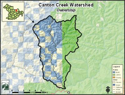
| Percent Public Ownership | 77 |
| Miles of anadromous salmonid streams | 36 |
| Highest elevation (feet) | 4,938 |
| Lowest elevation (feet) | 1,142 |
Location and Size
The Canton Creek fifth-field watershed is located in the northeastern portion of the Umpqua Basin. It is composed of 40,546 acres and includes 7.3 miles of Canton Creek, a major tributary to Steamboat Creek. The watershed stretches a maximum of 13 miles north to south, and 9 miles east to west.
E&S Environmental Chemistry
View large image
|
View as PDF
Landscape and Features
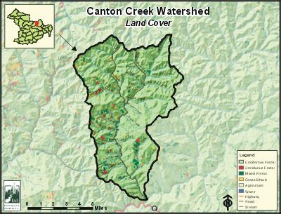
The Canton Creek Watershed has fairly consistent high relief topography, with about nine percent on exceptionally steep slopes. Elevations range from 4,938 feet at Chilcoot Mountain on the eastern boundary to 1,142 feet near the lowest reaches of Canton Creek. The watershed is characterized by a high density of streams that deeply dissect the landscape. Canton Creek is a mostly confined depositional stream that moves water at high velocity between step-pools where the water slows and material is deposited in the channel. Stream material deposited tends to be larger cobble size stones, rather than finer gravels due to the velocity of the water movement.
The nearest population center is the unincorporated community of Idleyld Park located approximately 16 miles west of Canton Creek along Highway 138. Glide is a larger unincorporated town located three miles further west. There are no residents living within the Canton Creek Watershed boundary. Major roads within the area include the Canton Creek Road (BLM Road 25-1E-31) that originates from Steamboat Creek Road (Forest Service Road 3803) near its intersection with Highway 138. The Canton Creek Road follows north through the watershed along Canton Creek.
The most common land use in the watershed is Federal Reserve management where there is no commercial timber harvest. Most of the Federal Reserve areas are located in contiguous areas in the north and east, in alternating section blocks in the northwest, and along major streams in the south end of the watershed. The rest of the watershed is primarily used for public and private forestry. Land ownership is primarily public (77%), managed by the Bureau of Land Management in the west and the Forest Service to the east. Private industrial landowners make up the remaining 23% of the watershed.
Current Conditions
The Canton Creek Watershed has 36 stream miles of anadromous salmonid habitat. The watershed provides habitat for summer and winter steelhead, and searun and resident cutthroat trout. Coho and spring Chinook salmon have been observed in the lower reaches of Canton Creek but the habitat does not support salmon runs of those species.
Most streams in the watershed have conifer forest-dominated riparian areas. However, some streambank areas have large amounts of red alder. This is more common where the soil has been highly disturbed by historic logging practices and active stream channel flooding and erosion.
E&S Environmental
View large image
|
View as PDF
Early harvested riparian areas (prior to 1972) removed trees to the streambank along many of the major streams. Harvest since then has required no harvest buffers of various sizes along many streams, including all fish-bearing streams. Many of the early harvested riparian areas are now producing trees of sufficient size to again provide some riparian function for streams. Road construction began in the 1940s and 1950s when many of the main roads were built following close to stream channels removing riparian vegetation. ODFW stream habitat surveys suggest that many of the riparian areas surveyed are in fair to good condition in the Canton Creek Watershed but the streams lack sufficient levels of large woody material, essential for fish habitat in these stream systems. This indicates that although current levels of large woody material in streams are in short supply, there may be large wood available in the future from riparian areas that will help improve fish habitat. Improving riparian conditions on Pass Creek and Canton Creek are a high priority for addressing elevated stream temperatures and high velocity peak flows.
As is common in southwestern Oregon, stream temperature limits water quality in many of the streams throughout the watershed. Four streams in the Canton Creek Watershed are on the ODEQ 303(d) list for stream temperature: Canton Creek, East Pass Creek, Mellow Moon Creek, and Scaredman Creek. Increased temperatures are attributed to increases in disease and poorer health for salmonids. Numerous other streams have warm temperatures that could limit salmonid rearing in these reaches. Canton Creek is also listed for sediment, but a request to remove the sediment listing by the Forest Service is being reviewed by ODEQ.
Precipitation in the region is high with an average of over 63 inches per year measured at Idleyld Park. Most of the watershed is within the transient snow zone over 2,000 feet in elevation. These areas are prone to rain-on-snow events that can dramatically increase stream flows in a short period of time, causing substantial flooding and scouring of streambeds and surrounding vegetation. In 1964, a very large flood event from rain-on-snow storms caused substantial scouring of riparian vegetation and streambed material such as gravel and large wood, moving and depositing it further downstream. Peak flow events commonly trigger landslides including debris flows that radically alter habitat in streams. Several stream channels in the watershed have been scoured to bedrock by these events. Peak flows also eliminate winter habitat for young salmonids, flushing them downstream, thus reducing the salmon population in many areas.
Sources
Winn, Lisa A. Rock Creek Region Assessment and Action Plan. Roseburg, Oregon: Prepared for the Umpqua Basin Watershed Council and Roseburg Bureau of Land Management; 2006 June.
Umpqua


