 INSTITUTE FOR NATURAL RESOURCES
Oregon Explorer Top Menu
You are here
Watersheds
Landscapes and Ecosystems
Clearwater River-North Umpqua River Watershed
Key Statistics
| Size (acres) | 49,599 |
| Percent public ownership | 100 |
| Miles of anadromous salmonid streams | 0 |
| Highest elevation (feet) | 8,368 |
| Lowest elevation (feet) | 2,400 |
Location and Size
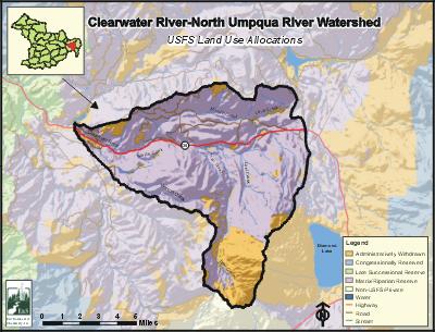
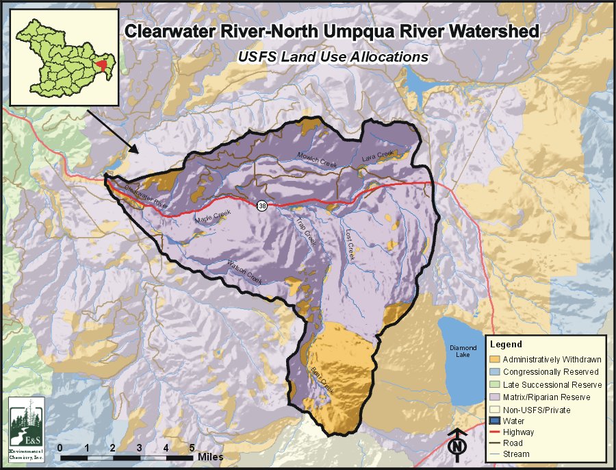
The Clearwater River-North Umpqua River fifth-field watershed is located in the eastern portion of the Umpqua Basin. The watershed is 49,599 acres and includes the entire Clearwater River drainage, a tributary to the North Umpqua River at Toketee Reservoir. The Clearwater River-North Umpqua River Watershed stretches a maximum of 12 miles north to south and 13 miles east to west.
E&S Environmental Chemistry
View large image
|
View as PDF
Landscape and Features
Topography within the Clearwater River-North Umpqua River Watershed is a mix of steep and gently sloping topography. Elevations range from 8,368 feet at Mount Bailey on the southeastern edge of the watershed to 2,400 feet where the Clearwater River empties into The North Umpqua River. Other high-elevation areas include Pig Iron Mountain (5,400') and Trap Mountain (6,133'). Streams within the watershed deeply dissect the landscape. Watson Falls, created where Watson Creek tumbles over the edge of a thick lava flow, is 272 feet tall, the tallest waterfall in southern Oregon.
Alpine glaciation has sculpted the higher elevations in the watershed. Residual glacial debris formed the eastern edge of the watershed against the Diamond Lake Watershed. Though the eruption of Mount Mazama (Crater Lake Caldera) about 7,000 years ago did not result in extensive deposits of pumice and ash within the watershed, remnants of water-deposited pumice remain in some of the lower valleys.
The only residents of the watershed live in PacifiCorp housing at Clearwater Village or in U.S. Forest Service housing at the Diamond Lake Ranger Station at the north end of the watershed. There are no incorporated cities within the watershed. The only major road within the watershed is State Highway 138 (the North Umpqua Highway), which parallels the Clearwater River through most of the watershed. There are U.S. Forest Service roads throughout the watershed, including Forest Road 37.
The most common land use in the Clearwater River-North Umpqua River Watershed is forestry, with nearly the entire land base used for public forestry. A power plant, water canal, and other PacifiCorp hydropower facilities occupy a small portion of the watershed. Land ownership is solely public, with administration by the U.S. Forest Service. Most of the watershed is managed as matrix lands. Matrix lands are those available for timber management at varying levels. A small portion of the watershed in the southern tip is managed as the Oregon Cascades Recreation Area.
Current Conditions
The Clearwater River-North Umpqua River Watershed contains habitat for brook trout and rainbow trout. Brown trout spawn in the lower reach of Clearwater River near Toketee Lake. The watershed's fish community is simple, due primarily to the lack of connectivity to the lower North Umpqua River and to the cold stream temperatures of the Clearwater River system.
Two tributaries of Clearwater Creek are on the final 2002 ODEQ 303(d) list for summer stream temperature.
Fish habitat conditions in the watershed range from fair to high quality. Low water temperatures are thought to limit production throughout much of the system. Water flow in the Clearwater River below Stump Lake has been reduced by hydroelectric water diversion. Gravel and woody material recruitment and the stream velocity to scour pools have been reduced in this area.
Timber harvest and road construction in riparian areas and past stream clean out have reduced recruitable and in-stream large woody debris, increased sediment, and reduced pools in some stream segments.
Sources
ODEQ 303(d) list: http://www.deq.state.or.us/wq/assessment/rpt02/gis02.zip. Accessed on-line on January 13, 2006.
USFS Watershed Analyses: Lower Clearwater Watershed Analysis. Diamond Lake Ranger District, Umpqua National Forest. October, 1999, and Upper Clearwater Watershed Analysis. Diamond Lake Ranger District, Umpqua National Forest. 1996.


