 INSTITUTE FOR NATURAL RESOURCES
Oregon Explorer Top Menu
You are here
Coastal Planning
Coast, Ocean, and Marine
Current and Historic Coastal Land Use

Map by John Ame
Note: Oregon's Coast Range is defined here as all of the Coast Range hydrological province and part of the Willamette hydrological province. The Coastal Zone is defined here as the area extending from the Washington border to the California border, between the crest of the coast range, and three miles out to sea.
The State of Oregon is a major landowner in its own coastal zone. Over 75,000 acres of forests, parks and estuaries are managed by state agencies. This figure doesnt include ocean beaches, lakes, non-tidal rivers or the ocean.
Over 1.7 million acres of land in the coastal zone are owned and managed by the federal government.
Current Land Use in Oregon's Coast Range
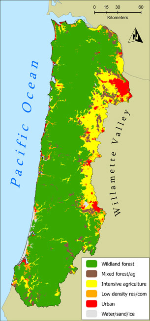
Cartography by Keith Olsen, CLAMS, OSU.
The soils and climate of the Oregon Coast Range are among the best in the world for growing trees. Consequently, 80% of the Oregon Coast is zoned for forest use. Scholars, land managers, and activists disagree about the original extent of old-growth forests in the coast range. A number of researchers have estimated that old-growth forests (often defined as stands 175 years old or older) covered approximately 50 percent of western Oregon in the early 1800s, though some estimates range considerably higher. More recently, studies have shown that older conifer cover declined by 63% between 1939 and 1993. Today less than 5% of the province is covered by old growth.
| Land Use | Acres | Percentage |
| Forest | 5,396,121 | 75.6 |
| Mixed Forest/Ag | 276,509 | 3.87 |
| Intensive Ag | 892,504 | 12.5 |
| Low density residential/commercial | 294,828 | 4.13 |
| Urban | 207,601 | 2.91 |
| Sand/beach/water | 69,843 | .98 |
Table Source: Oregon Dept. of Forestry, 2005
Historical Land Use in Oregon's Coast Range
Along the coast itself, extensive areas of wetlands have been converted to other uses through diking and draining, vegetative clearing and/or filling. For example, the following images show historic and converted wetland areas around Tillamook Bay.
These historic changes set the stage for land use issues today.


Kilchis Watershed Analysis, Bruce Follansbee, Ph.D., Senior Scientist
Compiled by John Ame, Science Writer (2008)
Sources
CLAMS: Kennedy, Rebecca S.H.; Spies, Thomas A. Forest cover changes in the Oregon Coast Range from 1939 to 1993. Forest Ecology and Management. 200: 129-147. http://www.fsl.orst.edu/clams/
LCDC A Citizens Guide to the Oregon Coastal Management Program https://www.oregon.gov/lcd/Pages/index.aspx
Oregon Blue Book: https://sos.oregon.gov/blue-book
Oregon State University: News and Communication Services; https://today.oregonstate.edu/archives/2007/dec/coast-range-landslides-historic-reality-pacific-northwest


