A COLLABORATION OF: OSU LIBRARIES & PRESS  INSTITUTE FOR NATURAL RESOURCES
INSTITUTE FOR NATURAL RESOURCESOregon Explorer Top Menu
You are here
Drinking Water Mapping Application to Protect Source Waters (DWMAPS)
Rivers, Streams, and Lakes
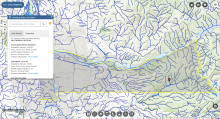
DWMAPS is an online mapping tool developed by the Environmental Protection Agency (EPA) that helps state and utility drinking water professionals update their source water assessments and protection plans in concert with other state and local mapping tools. DWMAPS can be used to locate drinking water providers, potential sources of contamination, polluted waterways as well as information on funded protection projects.


