 INSTITUTE FOR NATURAL RESOURCES
Oregon Explorer Top Menu
You are here
Wetlands
Landscapes and Ecosystems
Estuary Maps from the 1978 Estuary Inventory Project
The maps on this page are from the Oregon State University Libraries' Scanned Maps Collection. For more recent maps visit Oregon Wetlands Geodatabase on this site or use our Oregon Explorer Map Viewer.
Estuary Maps
These estuary habitat maps were created by the Oregon Division of State Lands in 1972 and 1973, updated in 1978 and 1979 by the Oregon Department of Fish and Wildlife for its series on Oregon's estuaries (the "Raccoon Reports," available as pdfs from OSU Library's Scholars Archive), and were updated again in DLCD's 1987 Oregon Estuary Plan Book.. These maps allow analysis of changing habitats over time and with development or restoration of estuary resources.
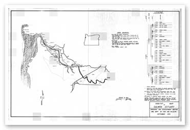
Habitat map of the Salmon River Estuary
(courtesy of Oregon State University
Libraries' Scanned Maps Collection)
View original image

Habitat map of the Sand Lake Estuary
(courtesy of Oregon State University
Libraries' Scanned Maps Collection)
View original image

Habitat map of the Siletz Estuary
(courtesy of Oregon State University
Libraries' Scanned Maps Collection)
View original image

Habitat map of the Umpqua estuary
(courtesy of Oregon State University
Libraries' Scanned Maps Collection)
View original image

Habitat map of the Chetco Estuary:
Photo courtesy of Oregon State University
Libraries' Scanned Maps Collection
View original image

Habitat map of the Coquille Estuary
(courtesy of Oregon State University
Libraries' Scanned Maps Collection)
View original image
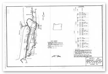
Habitat map of the Necanicum Estuary:
Photo courtesy of Oregon State University
Libraries' Scanned Maps Collection
View original image

Habitat map of the Rogue Estuary
(courtesy of Oregon State University
Libraries' Scanned Maps Collection)
View original image
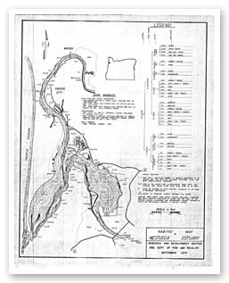
Habitat map of the Nestucca Estuary
(courtesy of Oregon State University
Libraries' Scanned Maps Collection)
View original image
Compiled by Heather Stout, Project Manager, Oregon Wetlands Explorer (2009) and John A. Christy, Portland State University-INR (2012).
Sponsored by


