 INSTITUTE FOR NATURAL RESOURCES
Oregon Explorer Top Menu
You are here
Wetlands
Historical Wetland Maps
The maps on this page are from the Oregon State University Libraries' Scanned Maps Collection. For more recent maps visit Oregon Wetlands Geodatabase on this site or use our Oregon Explorer Map Viewer.
Historical Wetland Maps
These maps were created in 1912 as part of a federal survey of kelp beds of the Pacific Coast (see: Cameron, F.K., W. C. Crandall, G. B. Rigg & T. C. Frye. 1915. Potash from kelp. U.S. Department of Agriculture Report 100. Government Printing Office, Washington, D.C. 122 pp. + 51 plates). Kelp has been used for millenia and around the world as a readily available source of phosphorus, potash, and iodine. The kelp survey of 1912 investigated the potential to extract potash and acetone from kelp for use in manufacturing gunpowder during World War I, when supplies of potash from Germany were not available. (See also: Neushul, P. 1989. Seaweed for war: California's World War I kelp industry. Technology and Culture 30: 561-583).
These historical maps showing the distribution of kelp beds along the coast of Oregon have been used by modern researchers to monitor changes in the locations and extent of kelp beds over the intervening century.
![Map of Central Oregon Coast [Lincoln City to Newport] kelp resources from 1912 study of fertilizer resources](/portal_images/wetlands/content_images/map1.jpg)
Kelp Map, Pacific Coast Oregon. Sheet 20.[Central Oregon Coast - Lincoln City to Newport]. Kelp resources
from 1912 study of fertilizer resources
(courtesy of Oregon State University
Libraries' Scanned Maps Collection)
View original image
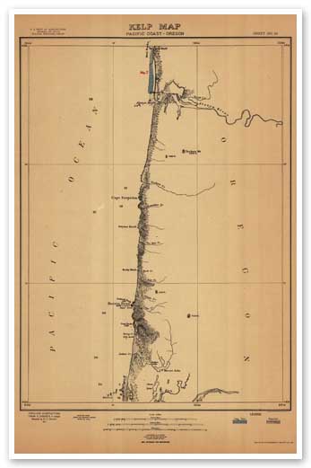
Kelp Map, Pacific Coast Oregon. Sheet 21. [Central Oregon Coast - Waldport to Florence] kelp resources
from 1912 study of fertilizer resources
(courtesy of Oregon State University
Libraries' Scanned Maps Collection)
View original image

Kelp Map, Pacific Coast Oregon. Sheet 23.[South Central Oregon Coast] kelp resources
from 1912 study of fertilizer resources
(courtesy of Oregon State University
Libraries' Scanned Maps Collection)
View original image

Kelp Map, Pacific Coast Oregon. Sheet 24.[Mid-South Oregon Coast] kelp resources
from 1912 study of fertilizer resources
(courtesy of Oregon State University
Libraries' Scanned Maps Collection)
View original image

Kelp Map, Pacific Coast Oregon. Sheet 25. [Southern Oregon Coast] kelp resources
from 1912 study of fertilizer resources
(courtesy of Oregon State University
Libraries' Scanned Maps Collection)
View original image
Compiled by Heather Stout, Project Manager, Oregon Wetlands Explorer (2009) and John A. Christy, Portland State University-INR (2012).
Sponsored by


