 INSTITUTE FOR NATURAL RESOURCES
Oregon Explorer Top Menu
You are here
Umpqua
Little River Watershed
Key Statistics
| Size (acres) | 131,800 |
| Percent public ownership | 59 |
| Miles of anadromous salmonid streams | 70 |
| Highest elevation (feet) | 5,299 |
| Lowest elevation (feet) | 669 |
Location and Size
The Little River fifth-field watershed is located in the central portion of the Umpqua Basin. The watershed is 131,853 acres, stretching a maximum of 13 miles north to south and 24 miles east to west. Little River flows into the North Umpqua River, 18 miles east of Roseburg, Oregon.

E&S Environmental Chemistry
View large image
Landscape and Features
The Little River watershed ranges in elevation from 730 to 5,275 feet, and is in the transitional zone where the coniferous forest of the western Cascade Mountains meets the eastern edge of the mixed hardwoods, prairies, and conifers of the Umpqua Valley hills.
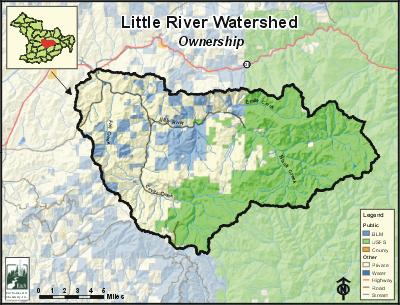
The most common land use in the Little River watershed is forestry, (97%) while agriculture constitutes less than 1% of the land use. Sixty-three percent of the watershed is public land administered by the US Forest Service (63,575 acres) and the Bureau of Land Management (19,802 acres). The remaining 37% (44,772 acres) is private land. Most of the private land (73%) are in blocks greater than 40 acres and are managed as industrial forest. Most of the homes are in the lower portions of Little River and Cavitt Creek where people operate small ranches or otherwise live in a rural setting.
The majority of the Little River Watershed is designated as the Little River Adaptive Management Area under the Northwest Forest Plan. Adaptive Management Areas are locations designated for research and exploratory management activities, including innovation in ecosystem management, science, community collaboration, and technical applications. It is the smallest of the ten Adaptive Management Areas at 82,865 acres.
There are no large population centers in the Little River Watershed. The unincorporated community of Glide is the nearest population center. Some rural residents on the outskirts of Glide live within the watershed's boundary. Based on the 2000 census, an estimated 1,200 people live in the Little River watershed (mostly along Little River Road and Cavitt Creek Road).
E&S Environmental Chemistry
Current Conditions
As one of the largest tributaries of the North Umpqua River, Little River supports a diverse assemblage of fish species including five anadromous salmonids. Anadromous fish species known to be present in the watershed include spring chinook salmon, coho salmon, steelhead trout, Pacific lamprey, and sea-run cutthroat trout. Non-anadromous salmonid species known to inhabit the watershed include resident rainbow trout, resident cutthroat trout, brook trout, and kokanee salmon. Although the North Umpqua River produces fewer coho salmon than the South Umpqua River, the Little River provides a large proportion of the spawning and rearing habitat in the North Umpqua subbasin. Conversations with state fish biologists have indicated that Little River, specifically Cavitt Creek, is considered to be one of the primary producers of coho salmon in the North Umpqua River sub-basin.
According to the Little River Watershed Analysis conducted by the US Forest Service and Bureau of Land Management in 1995, the majority of the riparian zones are characterized by narrow bands of small trees. In general, large trees have been selectively removed. However, between Negro Creek and Clover there is a relatively contiguous stand of old growth conifer, providing a significant potential source of large wood, as well as providing shade to the stream. There is also a lack of large wood in stream channels, and annual wood deposits in the lower river areas were being removed by private landowners. Highly degraded habitat conditions were apparent in Black, White, Jim, Fall, Copperhead, and Boulder Creeks, while relatively pristine conditions were found on Flat Rock Branch, Middle Emile Creek, Cultus creeks. Overall, the majority of the streams were considered to be in a degraded condition. According to the Oregon Department of Fish and Wildlife (ODFW) surveys, there are 22 falls, 13 culverts, three dams, and one boulder chute within the Little River Watershed.
A TMDL (Total Maximum Daily Load) analysis was conducted for the Little River Watershed in 2002. Once a TMDL has been completed, streams are removed from the ODEQ 303(d) list of water quality impaired streams, and guidance is provided to improve water quality conditions. The most important water quality concerns in the watershed are water temperature (in the summer), pH, and flow modification. A total of 66 stream miles, including most of the major tributary streams in addition to the mainstem of Little River, were considered to be water quality limited due to high water temperatures in the summer months. Forty-one miles of streams were water quality limited for sediment and flow modifications. A Water Quality Management Plan (WQMP) was developed by ODEQ to address these concerns.
Compiled by Jay Walters, private consultant, Barnes and Associates (2006)
Umpqua


