 INSTITUTE FOR NATURAL RESOURCES
Oregon Explorer Top Menu
You are here
Watersheds
Lower Cow Creek Watershed
Key Statistics
| Size (acres) | 102,537 |
| Percent Public Ownership | 39 |
| Miles of anadromous salmonid streams | 105 |
| Highest elevation (feet) | 4,028 |
| Lowest elevation (feet) | 628 |
Location and Size
The Lower Cow Creek fifth-field watershed is located in the southwestern portion of the Umpqua Basin. The watershed is 102,537 acres and includes the final 26 miles of Cow Creek. The watershed stretches a maximum of 13 miles north to south and 18 miles east to west.
E&S Environmental Chemistry
View large image
|
View as PDF
Landscape and Features
Most of the Lower Cow Creek Watershed has fairly steep topography. Elevations range from 4,028 feet at Grayback Mountain on the southern tip of the watershed to 628 feet where Cow Creek meets the South Umpqua River. Other high-elevation areas include Rabbit Mountain, Dutchman Butte, and Iron Mountain. Streams within the watershed deeply dissect the landscape. Cow Creek Valley is the watershed's only large, low elevation area. The valley opens up into a large floodplain downstream from the confluence with Council Creek until it joins with the South Umpqua River.
The only incorporated city within the Lower Cow Creek Watershed is Riddle. The City of Riddle is located within Cow Creek Valley in the northeastern section of the watershed. In 2000, the population of Riddle was 1,014 people. Using data from the 2000 census, the population of the Lower Cow Creek Watershed is estimated to be no more than 2,680 people.The only major road within the watershed is Cow Creek Road, which follows Cow Creek through the length of the watershed.
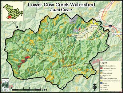
The most common land use in the Lower Cow Creek Watershed is forestry, with 91% of the land base used for public or private forestry. Agriculture constitutes 6% of the land use and mostly occurs in Cow Creek Valley. Land ownership is primarily private (60%), with public ownership (39%) mostly administered by the Bureau of Land Management. Lands belonging to City of Riddle, Douglas County, the State of Oregon, and the Cow Creek Band of Umpqua Tribe of Indians each total approximately 1% of the watershed.

E&S Environmental
View large image
|
View as PDF
Current Conditions
The Lower Cow Creek Watershed provides habitat for winter steelhead, cutthroat trout, coho, and fall chinook. Spring chinook have been documented in the watershed but their presence is intermittent and does not constitute a salmon run. Within the Lower Cow Creek Watershed, largescale suckers and Umpqua pikeminnows are generally only found in the lower third of Cow Creek. Smallmouth bass have been found as far as Salt Creek. Other warm water fish, such as largemouth bass and yellow perch, have also been reported in the watershed. These fish are most likely introduced to watershed streams through private ponds or migrate into Cow Creek from the South Umpqua River.

Photo courtesy of Partnership
for the Umpqua Rivers
Since most of this watershed is used for forestry, it is not surprising that most tributary streams in the Lower Cow Creek Watershed have conifer forest-dominated riparian areas. Cow Creek's riparian areas are predominantly thin strips of hardwoods intermixed with brush and blackberries. Oregon Department of Fish and Wildlife (ODFW) stream habitat surveys conducted during the summers of 1993 through 1995 suggest that many of the watershed's tributary streams lack sufficient levels of large woody debris (ODFW did not survey Cow Creek).
Within the watershed, Cow Creek, Cattle Creek, Iron Mountain Creek, Martin Creek, Middle Creek, and South Fork Middle Creek are on the Oregon Department of Environmental Quality (ODEQ) 303(d) list for violating stream temperature standards. Cow Creek is also 303(d) listed for pH and chlorine, and ODEQ has found evidence of ammonia toxicity near the mouth. In addition, Cow Creek is considered water quality limited for habitat modification and flow modification and Middle Creek is water quality limited for flow modification.
Within the Lower Cow Creek Watershed, Middle Creek is the largest tributary to Cow Creek. Since 1997, acidic water and metals from the abandoned Formosa Mine have been contaminating approximately 18 miles of Middle Creek and South Fork Middle Creek. As a result, these two streams are mostly uninhabitable to fish. Acidic water and metals are reaching Middle Creek and South Fork Middle Creek through water flowing from the mine openings (adits) and from groundwater moving through the Formosa Mine workings. Cow Creek provides the City of Riddle with its drinking water supply. Fortunately, the contaminants found in Middle Creek and South Forth Middle Creek have not been detected in Cow Creek, indicating that the City of Riddle's drinking water supply is safe from Formosa Mine waste. ODEQ declared the Formosa Mine site a State Orphan site in March of 2000, a designation that enables ODEQ to use Oregon's Orphan account to fund short-term cleanup and follow-up environmental investigation.
Specific UBWC Enhancement Opportunities for the Lower Cow Creek Watershed
Compared to other watersheds in the Umpqua Basin, stream conditions in the Lower Cow Creek Watershed are good. UBWC staff members believe that within the Lower Cow Creek Watershed, Iron Mountain Creek and Table Creek are generally in the best condition. Shoestring Creek, Mitchell Creek, Russell Creek, Catching Creek, Council Creek, Cattle Creek, and Panther Creek are the UBWC's top priority streams for projects within the watershed. Listed below are specific UBWC enhancement opportunities within the Lower Cow Creek Watershed. These recommendations are based on the assessment findings as well as the professional experience of UBWC, DSWCD, and ODFW staff members.
1. Actively seek out opportunities with landowners, businesses, and resident groups in key areas to enlist participation in restoration projects and activities:
-
Remove/replace barriers to fish passage on Mitchell Creek, Shoestring Creek, and Buck Creek.
-
Install efficient irrigation systems and encourage instream water leasing on streams with irrigation rights, such as Cow Creek.
-
Place fish habitat improving logs and boulders in Russell Creek, Cattle Creek, and the lower reaches of Doe Creek.
-
Plant trees (especially conifers), remove blackberries, and fence riparian areas along Jerry Creek, Russell Creek, and Catching Creek, as well as at the mouth of other small tributaries flowing into Cow Creek. Install upland stock water systems as appropriate.
2. Work with landowners on a case-by-case basis on the following project types:
-
Improve instream fish habitat in areas with good riparian zones and an active channel that is less than 30 feet, especially Iron Mountain Creek, Beatty Creek, Salt Creek, Panther Creek, and Table Creek.
-
Assist landowners willing to create or improve wetlands, especially where evidence suggests historical wetlands may have been located, such as Cooper Creek and the lower reaches of Cow Creek.
3. Assist the Umpqua Basin Fish Access Team's evaluation of fish passage barriers and obstacles, especially on Council Creek, Cattle Creek, Salt Creek, and the upper third of Middle Creek and its tributaries.
4. Develop a page on the UBWC website that provides local information on wetlands and wetland conservation programs to help landowners enroll in programs that can benefit wetlands and meet landowner goals.
5. Develop educational materials and/or outreach programs to educate target audiences about fish habitat and water quality related issues:
-
Create educational brochures about bank erosion, the problems associated with channel modification, and the importance of riparian areas. These could be given to new landowners through real estate agents.
-
Develop public service announcements about ways of improving or maintaining riparian and instream conditions, such as the benefits of riparian fencing and how to use fertilizers and pesticides in a stream-friendly fashion.
-
Design engaging displays about fish passage barriers for community events, such as the Douglas County Fair.
-
Give presentations at citizen groups about the benefits to landowners and to fish that result from upland stock water systems, off-channel shade trees, and instream water leasing.
6. Support local fish habitat and water quality research:
-
Train volunteers to conduct fish and water quality monitoring and research.
-
Provide equipment necessary for local water quality research and monitoring.
-
Survey long-term landowners and residents about historical and current fish distribution and abundance.
-
Encourage school and student participation in monitoring and research.
-
Collaborate with other organizations and agencies on monitoring projects, such as assisting ODEQ with monitoring pH and metals on Middle Creek.
7. Educate policy makers about the obstacles preventing greater landowner participation in voluntary fish habitat and water quality improvement methods.
Sources
Geyer, Nancy A. Lower Cow Creek Watershed Assessment and Action Plan. Roseburg, Oregon: Prepared for the Umpqua Basin Watershed Council; 2003 November.


