 INSTITUTE FOR NATURAL RESOURCES
Oregon Explorer Top Menu
You are here
Watersheds
Lower Smith River-Lower Umpqua River Watershed
Key Statistics
| Size (acres) | 140,917 |
| Percent public ownership | 69 |
| Miles of anadromous salmonid streams | 203 |
| Highest elevation (feet) | 2,851 |
| Lowest elevation (feet) | Sea level |
Location and Size
The Lower Smith River fifth-field watershed is located in the northwestern portion of the Umpqua Basin, and drains into the Umpqua River near the Pacific Ocean. The watershed is approximately 140,917 acres, stretching 19 miles north to south and 20 miles east to west. The watershed begins at confluence of the West Fork Smith River and extends downstream to the confluence of the Umpqua River.
E&S Environmental Chemistry
View large image
|
View as PDF
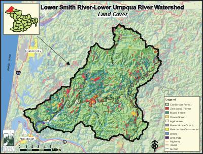
Landscape and Features
Elevations in the Lower Smith River Watershed range from sea level, where the Umpqua River estuary meets the Pacific Ocean, to 2,851 feet in the northern portion of the watershed. Most of the northeastern portion of the watershed is fairly steep with stream channels that dissect the landscape.
Forestry is the predominant land use in the Lower Smith River Watershed, accounting for approximately 96% of the watershed. Agriculture and livestock land use constitute about 3% of the watershed, occurring mostly in the floodplains of the Smith River. All other land use accounts for 1% of the watershed. Seventy percent of the watershed is publicly owned, 42% of which is managed by the US Forest Service (USFS), and 27% by the Bureau of Land Management (BLM). State lands constitute about 1% of the watershed. Private lands account for 30% of the watershed, most of which is owned by large commercial timber companies.
The population of the Lower Smith River Watershed is concentrated in the Smith River valley, and consists of small homesteads, ranches, and rural residences. There are no large population centers within the watershed, although Reedsport is immediately across the Umpqua River from the confluence of the Smith River. The primary road in the watershed is Smith River Road, which enters the watershed near the rivermouth and follows the river eastward into the Upper Smith River Watershed.

E&S Environmental Chemistry
View large image
|
View as PDF
Current Conditions
The Lower Smith River Watershed is home to many fish species, including coho and chinook salmon, winter steelhead, and cutthroat trout. In addition to salmon and trout, many warm water fish, including largemouth bass, brown bullhead, and bluegill reside in the watershed, especially in the lower portion near the rivermouth. There are about 203 miles of anadromous salmonid streams within the Lower Smith River Watershed. Nearly all medium and large tributary streams within the watershed are used by coho salmon and winter steelhead for spawning and rearing. The Smith River downstream of the confluence of the North Fork is used primarily for rearing and migration. Fall chinook salmon spawning and rearing habitat is found in Perkins, Wassin, Buck, Vincent, Johnson, and Spencer creeks, as well as in the upper reaches of the North Fork and West Fork Smith rivers. There are no comprehensive data about resident cutthroat distribution in the Lower Smith River Watershed, but resident cutthroat are generally limited to small tributaries above the ranges of anadromous fish.
According to Oregon Department of Fish and Wildlife data, there are 10 culverts, 11 falls, and three dams that may be barriers or obstacles to juvenile salmon passage in the Lower Smith River Watershed. A fish ladder at Smith River Falls, a natural waterfall, allows upstream passage of adult salmon. Large woody debris is generally lacking throughout the watershed, but overall fish habitat conditions are better than average in the Lower Smith River Watershed, compared with other coastal Oregon systems.
Several rivers in the watershed are included on the Oregon Department of Environmental Quality's (ODEQ) 303(d) list of water quality-limited streams. The North Fork Smith River, West Fork Smith River, and mainstem of the Smith River between the North Fork and West Fork are listed for water temperature exceedances in the summer months. In addition, several smaller tributary streams of the North Fork are listed for water temperature, including the West Branch of the North Fork, and the Middle Fork of the North Fork Smith River. The ODEQ is currently completing a Total Maximum Daily Load (TMDL) analysis for the Umpqua Basin, including Lower Smith River, which will provide guidance for improving water quality conditions.
Compiled by Jay Walters, private consultant, Barnes and Associates (2006)


