 INSTITUTE FOR NATURAL RESOURCES
Oregon Explorer Top Menu
You are here
Watersheds
Lower South Umpqua River Watershed
Key Statistics
| Size (acres) | 110,419 |
| Percent Public Ownership | 2 |
| Miles of anadromous salmonid streams | 68 |
| Highest elevation (feet) | 3,458 |
| Lowest elevation (feet) | 358 |
Location and Size
Located in the west-central portion of the Umpqua Basin, the Lower South Umpqua fifth-field watershed is 110,419 acres. The watershed includes the final 25 miles of the South Umpqua River and its tributaries. The Lower South Umpqua Watershed is a maximum of 12 miles north to south and 24 miles east to west.
E&S Environmental Chemistry
View large image
|
View as PDF
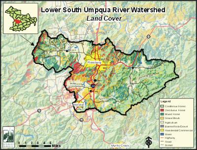
Landscape and Features
Most of the Lower South Umpqua Watershed is characterized by broad valleys and gently sloping hills, with elevations ranging from 500 to 1,000 feet. The lowest point in the watershed is 358 feet at the mouth of the South Umpqua River. As the watershed approaches the Cascades in the east, the landscape becomes more mountainous, reaching a maximum elevation of 3,458 feet at Lane Mountain. The Lower South Umpqua Watershed's largest tributary is Deer Creek. The Deer Creek stream system drains approximately 43,090 acres of land, or 39% of the Lower South Umpqua Watershed.
The Lower South Umpqua Watershed is the most heavily populated watershed in Umpqua Basin. The incorporated cities of Winston and Roseburg, and the population centers of Green, Shady, Melrose, and Dixonville, are all found within the watershed. Four major throughways transect the watershed: Interstate 5, Highway 99, Highway 42, and Highway 138.
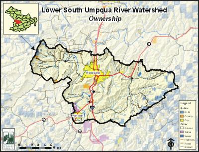
In the Lower South Umpqua Watershed, 58% of the land base is used for agriculture. Lands used for forestry account for 19% of the watershed, and are mostly located in the northwest. Residential and commercial/industrial lands constitute 23% of the land use and are found in and around the cities of Roseburg and Winston, and in Melrose, Green, and Shady. Land ownership is primarily private (94%), with public ownership evenly divided among the Bureau of Land Management, the City of Roseburg, and county and state lands.
E&S Environmental Chemistry
View large image
|
View as PDF
Current Conditions
Coho, winter steelhead, spring chinook, fall chinook, and cutthroat trout can all be found in the Lower South Umpqua Watershed. According to Oregon Department of Fish and Wildlife (ODFW) aerial counts of fall chinook, each year around one-forth of the fall chinook counted in the South Umpqua River are in the Lower South Umpqua Watershed. Fall chinook have also been documented in Deer Creek.
Two non-native fish, smallmouth bass and brown bullhead, have resident populations in the South Umpqua River and possibly in the lower reaches of Deer Creek. Other introduced fish, including largemouth bass, yellow perch, and bluegill, may also have intermittent populations in the watershed.
Riparian areas in the Lower South Umpqua Watershed are predominantly thin strips of hardwoods mixed with shrubs, grass, rangeland, and blackberries. Along the South Umpqua River, many areas have no vegetation.
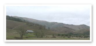
Photo courtesy of Partnership for the Umpqua Rivers
ODFW conducted stream habitat surveys in Newton Creek and in the Deer Creek stream system. Data from these surveys suggest poor levels of large woody debris limit fish habitat in these streams. However, not enough surveys have been conducted in the Lower South Umpqua Watershed to draw any conclusions about watershed-wide conditions.
In the Lower South Umpqua Watershed, three streams are included on the Oregon Department of Environmental Quality (ODEQ) 303(d) list for water quality impairment: Deer Creek, North Fork Deer Creek, and the South Umpqua River. Deer Creek is listed for temperature, fecal coliform, and dissolved oxygen. North Fork Deer Creek is listed for E. coli. The South Umpqua River is listed for the following 10 parameters: Temperature, fecal coliform, biological criteria, phosphorus, pH, aquatic weeds/algae, chlorine, arsenic, cadmium, and dissolved oxygen. The following streams are considered water quality limited for habitat or flow modification: Champagne Creek (flow), Roberts Creek (flow), Deer Creek (habitat and flow), North Fork Deer Creek (flow), South Fork Deer Creek (flow), and the South Umpqua River (habitat and flow).
Specific UBWC enhancement opportunities for the Lower South Umpqua Watershed (excluding Deer Creek)
1. Actively seek out opportunities with landowners, businesses, and resident groups in key areas to enlist participation in the following restoration projects and activities: · Future stream habitat surveys (all but Newton Creek).
- Instream structure placement (case-by-case basis).
- Improve irrigation efficiency and instream water leasing (all streams with water rights).
- Riparian planting, blackberry conversion, fencing, and alternative livestock watering systems, especially on the South Umpqua River, Champagne Creek, Roberts Creek, and Marsters Creek.
2. Work with interested landowners on a case-by-case basis on the following project types:
- Improve instream fish habitat in areas with good riparian zones and an active channel that is less than 30 feet.
- Enhance and/or protect riparian zones and wetlands to improve wildlife habitat, fish habitat, and water quality conditions.
3. Develop educational materials and/or outreach programs to educate target audiences about fish habitat and water quality-related issues:
- Create educational brochures about bank erosion, the problems associated with channel modification, and the importance of riparian areas. These could be given to new landowners through real estate agents.
- Develop public service announcements about ways of improving or maintaining riparian and instream conditions, such as the benefits of riparian fencing and how to use fertilizers and pesticides in a stream-friendly fashion.
- Design engaging displays about fish passage barriers for community events, such as the Douglas County Fair.
- Give presentations at citizen groups about the benefits to landowners and to fish that result from upland stock water systems, off-channel shade trees, and instream water leasing.
4. Support local fish habitat and water quality research:
- Train volunteers to conduct fish and water quality monitoring and research.
- Provide equipment necessary for local water quality research and monitoring.
- Survey long-term landowners and residents about historical and current fish distribution and abundance.
- Encourage school and student participation in monitoring and research.
5. Enlist landowner participation to remove fish passage barriers as identified.
6. Educate policy makers about the obstacles preventing greater landowner participation in voluntary fish habitat and water quality improvement methods.
Deer Creek action plan
In this section, specific potential enhancement activities are listed by different sections of the Deer Creek Watershed, which can be located on the map below.
Deer Creek, Roseburg (12 miles of riparian area)
- Check point sources for bacteria and toxics.
- Plant trees and shrubs in riparian areas where there is less than 50% canopy cover (4 miles of riparian area).
- Conduct non-evasive blackberry removal and interplant with trees (1 mile of riparian area).
- Eastwood school: remove gravel area by creek and restore. Enhance riparian area at Eastwood Park and use as a demonstration site of riparian health with before/after displays.
- Enhance riparian area on Ramp Creek before it is converted into development and develop wetlands.
- Check for fish passage along Ramp Creek and correct passage problems if any are found. Restore meanders on Ramp Creek.
- Remove fill and concrete from Deer Creek streambanks. Require fish passing culverts in further developments. Purchase greenway easement along Deer Creek.
Canopy Cover over Deer Creek and its Tributaries. South Side of Deer Creek, from the Urban Growth Boundary to the forks (14.5 miles of riparian area)
- Concentrate tree planting on sections with less than 50% cover (5.5 miles of riparian area).
- Much of this section is already fenced, enhance those riparian areas.
- Establish conifers and other native vegetation in areas now dominated by blackberries (1 mile of riparian area). Several fields on DaMotta Branch have opportunities for livestock management, cattle crossings, off-channel watering, riparian planting and/or spring grazing lots.
- Increase riparian areas on DaMotta Branch on poor agricultural lands as wetlands and flood control.
- Evaluate channel modification and adjust.
North Side of Deer Creek, from the Urban Growth Boundary to Buckhorn Road (11 miles of riparian area) Sample for toxics.
- Check fish passage on Shick Creek.
- Enhance extensive areas along Shick Creek that are currently blackberry or rangeland with trees (2 miles of riparian area).
- Enhance created wetlands on Shick Creek and past restoration activities on Shick Creek Enhance riparian areas in abandoned mill site.
- Pursue livestock management opportunities in three major tributary drainages, including off-channel watering and shade.
- Concentrate tree planting on sections with less than 50% cover (7 miles of riparian area). Evaluate channel modification and adjust.
North Side of Deer Creek, Buckhorn Road to the forks (11.5 miles of riparian area)
- Pursue livestock management opportunities, concentrate on moving feeding areas away from the creek and unstable areas, and education.
- Enhance riparian areas with tree planting.
- Promote confidential program to dye-test near-stream septic systems to check for failure.
- Mitigate effects of past riprap.
North Fork Deer Creek, mouth to Strader Road (17 miles of riparian area)
- Pursue developing log pond and wetlands area, plantings of wet meadows and native prairie, and combine with livestock management.
- Focus riparian planting on areas with less than 50% cover (9 miles of riparian area).
- Establish trees and other native vegetation in areas now dominated by blackberries (2.5 miles of riparian area).
- Enhance riparian area at O. C. Brown Park and use as a demonstration site for riparian health.
- Perform livestock management with riparian fencing, cattle crossings, off-channel watering, off-channel provision of shade, and cross fencing.
- Place large woody material in the stream (low priority). Evaluate channel modification and adjust.
- Place large woody material in the stream (higher priority).
- Establish vegetation in areas where blackberries have been removed.
- Perform livestock management with riparian fencing, cattle crossings, off-channel watering, off-channel provision of shade and cross fencing.
- Promote confidential program to dye-test near-stream septic systems to check for failure (especially in the winter).
- Plant steep uplands with trees.
South Fork Deer Creek (68.5 miles of riparian area)
- Perform livestock management with riparian fencing, cattle crossings, off-channel watering, off-channel provision of shade, and cross fencing.
- Promote confidential program to dye-test near-stream septic systems to check for failure (especially in the winter).
- Establish trees and other native vegetation in areas now dominated by blackberries (2.5 miles of riparian area).
- Perform streambank erosion control emphasizing bioengineering techniques.
- Increase riparian areas on poor agricultural lands, that are often wet and cause foot diseases for livestock, or are borderline for hay production, as wetlands and flood control.
- Place large woody material in the stream on Middle Fork South Fork Deer Creek or South Fork Deer Creek above the confluence of Middle Fork South Fork Deer Creek.
- Evaluate channel modification and adjust.
- Plant steep uplands with trees.
- Encourage landowners to meter water intakes.
Deer Creek Outreach Programs
- Collaborate with local citizens and groups to develop volunteer-based fish habitat and water quality monitoring teams that would evaluate current local conditions and post-project success, identify critical salmonid spawning and rearing habitat, and work with private landowners to determine restoration opportunities.
- Implement public information and educational programs about the problems associated with culverts and other fish passage barriers, ways of identifying barriers, and opportunities to replace or retrofit problem culverts and other barriers.
- Cooperate with local citizen's groups and agencies to conduct public information and education programs about the importance and benefits of a healthy riparian habitat.
- Emphasize the potential funding sources for stock water management, riparian fencing, and riparian planting and conversions to encourage landowner participation.
- Develop public information and educational programs that focus on the public health hazards associated with bacteria and toxins in surface water and groundwater, common sources of toxins and bacteria, and methods to improve conditions at the local level.
- Through public information programs, encourage landowner participation in the Oregon Department of Environmental Quality's free, anonymous septic system testing service.
Riparian Plants
Generally suggested plant species for riparian areas in the Deer Creek Watershed:
- Douglas-fir
- incense cedar
- western red cedar
- ponderosa pine
- red alder
- bigleaf maple
- Oregon white oak
- Oregon ash
- willows
- white alder
- cascara buckthorn
- snowberry
- red-osier dogwood
- mock orange
- Pacific serviceberry
- ninebark
- sedges
- rushes
Smolt Trap
- Coordinate possible smolt trap monitoring at Eastwood School with science classes to educate and involve students with smolt counts, water quality, etc.
Sources
Geyer, Nancy A. Lower South Umpqua Watershed Assessment and Action Plan. Roseburg, Oregon: Prepared for the Umpqua Basin Watershed Council; 2003 July.
Kincaid, Heidi. Deer Creek Watershed Assessment and Action Plan. Roseburg, Oregon: Prepared for the Umpqua Basin Watershed Council; 2002 April.


