 INSTITUTE FOR NATURAL RESOURCES
Oregon Explorer Top Menu
You are here
Watersheds
Lower Umpqua River Watershed
Key Statistics
| Size (acres) | 67,930 |
| Percent Public Ownership | 22 |
| Miles of anadromous salmonid streams | 92 |
| Highest elevation (feet) | 1,939 |
| Lowest elevation (feet) | Sea level |
Location and Size
The Lower Umpqua River fifth-field watershed is located at the western-most edge of the Umpqua Basin, and drains directly into the Pacific Ocean. The watershed is approximately 67,930 acres, stretching a maximum of 7 miles north to south and 18 miles east to west. The watershed extends upstream from the mouth of the Umpqua River for 23 river miles to the confluence of Mill Creek, just below Scottsburg (approximately the head of tidewater).
E&S Environmental Chemistry
View large image
|
View as PDF
Landscape and Features
Elevations in the Lower Umpqua River watershed range from sea level, where the Umpqua River estuary meets the Pacific Ocean, to 1,866 feet in the eastern portion of the watershed. Most of the eastern portion of the watershed is fairly steep with stream channels that dissect the landscape. The western portion of the watershed contains little steep ground. The largest low relief features in the watershed are the Umpqua River estuary and the floodplains along the Umpqua River, upstream almost to the Luder Creek confluence. The lower reaches of Winchester Creek, Scholfield Creek, and Dean Creek also have fairly extensive floodplains. The Umpqua estuary is a unique and valuable asset to the watershed, providing important habitat for shellfish, marine fish, anadromous fish, birds, and other wildlife species. Tidal wetlands are highly productive systems, providing essential support to the food chain, including shelter, food, and habitat for juvenile salmon.
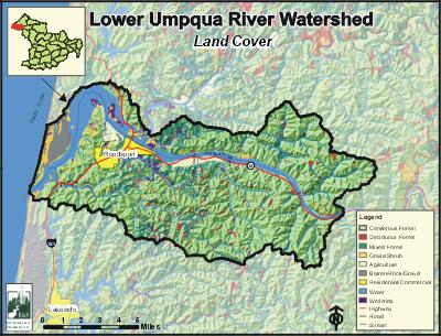
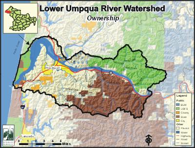
The most common land use in the Lower Umpqua River watershed is forestry, accounting for a little more than two-thirds of the watershed (69%). Forested lands are managed both publicly and privately. Agricultural land uses constitute about 3% of the watershed, occurring mostly in the floodplains of the lower Umpqua River and its tributary streams. Nearly half of the land in the watershed is publicly owned. The Elliott State Forest accounts for 28% of the watershed, and 22% is administered by the US Forest Service (USFS) and Bureau of Land Management (BLM). Private ownership accounts for 40%, and the remaining 10% of the land is covered by water. Private lands are located mostly in the western half of the watershed.
The population of the Lower Umpqua River watershed is concentrated in the Reedsport and Winchester Bay regions. Reedsport is the only incorporated city in the watershed. Highway 38 is the major east-west thoroughfare, paralleling the Umpqua River. Highway 101 runs north-south along the coast, crossing the Umpqua River at Reedsport.
E&S Environmental Chemistry
View large image
|
View as PDF
Current Conditions
The Lower Umpqua River Watershed is home to many fish species, including four native salmonid species. In addition to salmon and trout, many warm water fish, including largemouth bass, yellow perch, and bluegill reside in the watershed. There are about 92 stream miles of anadromous salmonid streams within the Lower Umpqua River watershed. According to the Oregon Department of Fish and Wildlife (ODFW), winter steelhead and coho use about 39% and 35%, respectively, of the potential available habitat. Summer steelhead, spring chinook, and fall chinook use 11% or less.All large tributary streams within the watershed are used for winter steelhead spawning. Chinook salmon spawning and rearing habitat is found along the lower reaches of Franklin Creek. There are no comprehensive data about resident cutthroat distribution in the Umpqua Basin, but resident cutthroat are generally limited to small tributaries above the ranges of anadromous fish.
According to ODFW data, there are no dams that are barriers or obstacles to adult or juvenile fish passage in the Lower Umpqua River watershed. However, seven culverts are identified as barriers to salmonid fish passage.
The length of the Umpqua River in this watershed was placed on the Oregon 303(d) water quality-limited list due to documented violations of water quality standards. In addition, Scholfield Creek is listed from the mouth to river mile five for bacteria. The most important water quality concerns in the watershed are fecal coliform bacteria and water temperature.
The upland portions of the watershed are mainly forested (62.3%) with coniferous forest stands, and almost two-thirds of the coniferous forests within the watershed are comprised of trees larger than 20 inches diameter at breast height (DBH). Hardwood forests comprise 6.8% of the watershed, and are more common along stream corridors and in some of the lower-elevation areas. Non-forested areas, including agricultural lands, tidal areas, and dunes, predominate in the lower portions of the watershed. According to ODFW stream surveys, riparian conditions were best in the upper reaches of Franklin Creek and Dean Creek. In general, riparian conditions deteriorated in a downstream direction. A similar pattern was found for large woody debris conditions, which were best in the upper reaches of Franklin Creek and throughout Charlotte Creek. Large woody debris conditions were uniformly poor in Winchester, Dean, and Butler Creeks, and nearly so in Scholfield Creek.
Compiled by Jay Walters, private consultant, Barnes and Associates (2006)


