 INSTITUTE FOR NATURAL RESOURCES
Oregon Explorer Top Menu
You are here
Watersheds
Middle South Umpqua River Watershed
Key Statistics
| Size (acres) | 59,441 |
| Percent Public Ownership | 13 |
| Miles of anadromous salmonid streams | 67 |
| Highest elevation (feet) | 3,247 |
| Lowest elevation (feet) | 517 |
Location and Size
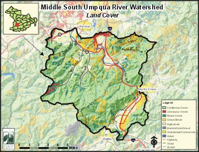
The Middle South Umpqua fifth-field watershed is located in the south-central portion of the Umpqua Basin. The watershed includes 22 miles of the South Umpqua River beginning at stream mile 47 (east of the City of Riddle) and ending at stream mile 25 (west of the City of Winston). The Middle South Umpqua Watershed is 59,441 acres and stretches a maximum of 11 miles north to south and 11 miles east to west.
E&S Environmental Chemistry
View large image
|
View as PDF
Landscape and Features
Most of the Middle South Umpqua Watershed's upland areas are characterized by gentle to moderately steep slopes. Elevations range from 517 feet at the river's confluence with Lookingglass Creek to 3,247 feet near Big Baldy Mountain along the southwestern border. Within the watershed, the South Umpqua River Valley becomes very wide where it enters the watershed, near the confluence with Clarks Branch Creek, and where it exits the watershed.
Three major roads transect the watershed: Interstate 5, Highway 99, and Highway 42. There is no incorporated city that is entirely within the Middle South Umpqua Watershed. A small portion of the City of Myrtle Creek falls within the watershed boundary, as do all of the Dillard and Tri-City areas.
Just over half of the land base within the Middle South Umpqua Watershed is used for forestry. Lands used for agriculture account for almost 40% of the watershed and are mostly located in the northeast and around Dillard and Tri-City. Approximately five percent of the watershed is used for industrial purposes, including aggregate gravel mining and lumber mills. Land ownership is primarily private (84%). Federal lands account for 13% of the watershed and are administered by the Bureau of Land Management.

E&S Environmental Chemistry
View large image
|
View as PDF
Current Conditions
Coho, winter steelhead, spring chinook, fall chinook, and cutthroat trout can all be found in the Middle South Umpqua Watershed. According to Oregon Department of Fish and Wildlife (ODFW) aerial counts of fall chinook, each year around two-thirds of the fall chinook documented in the South Umpqua River are within the Middle South Umpqua Watershed. Two non-native fish, smallmouth bass and brown bullhead, have resident populations in the South Umpqua River. Largemouth bass, yellow perch, and bluegill may also have intermittent populations in the watershed; these fish are most likely introduced into the South Umpqua River from private ponds.
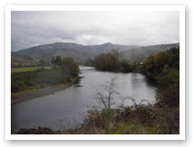
Photo courtesy of Partnership
for the Umpqua Rivers
Within the Middle South Umpqua Watershed, the South Umpqua River's riparian areas, and the riparian areas of most tributaries, are primarily thin strips of hardwoods interspersed with brush and blackberries. Conifers are the dominant riparian vegetation only in the uppermost reaches of a few streams. According to ODFW stream habitat surveys conducted during the summers of 1994 through 1996, many of the watershed's tributaries have poor levels of large woody debris and poor or fair pools.
In the Middle South Umpqua Watershed, Rice Creek and the South Umpqua River are on the Oregon Department of Environmental Quality (ODEQ) 303(d) list for temperature. The South Umpqua River is also 303(d) listed for fecal coliform, biological criteria, pH, chlorine, and aquatic weeds or algae. The following streams are considered water quality limited for habitat or flow modification: Clarks Branch Creek (habitat), Kent Creek (habitat and flow), Lane Creek (habitat and flow), Rice Creek (habitat and flow), the South Umpqua River (habitat and flow), and Willis Creek.
Specific UBWC Enhancement Opportunities in the Middle South Umpqua Watershed
1. Actively seek out opportunities with landowner and resident groups to enlist participation in restoration projects and activities:
-
Improve irrigation efficiency and instream water leasing (all streams with water rights). Riparian planting, blackberry conversion, fencing, and alternative livestock watering systems (especially the South Umpqua River from Rice Creek to Barrett Creek, Clarks Branch Creek, and Willis Creek).
2. Work with interested landowners on a case-by-case basis on the following projects:
-
Improve instream fish habitat in areas with good riparian zones and an active channel that is less than 30 feet.
-
Enhance and/or protect riparian zones and wetlands to improve wildlife habitat, fish habitat, and water quality conditions.
3. Develop educational materials and/or outreach programs to educate target audiences about fish habitat and water quality-related issues:
-
Create educational brochures about bank erosion, the problems associated with channel modification, and the importance of riparian areas. These could be given to new landowners through real estate agents.
-
Develop public service announcements about ways of improving or maintaining riparian and instream conditions, such as the benefits of riparian fencing and how to use fertilizers and pesticides in a stream-friendly fashion.
-
Design engaging displays about fish passage barriers for community events, such as the Douglas County Fair.
-
Give presentations at citizen groups about the benefits to landowners and to fish that result from upland stock water systems, off-channel shade trees, and instream water leasing.
4. Support local fish habitat and water quality research:
-
Train volunteers to conduct fish and water quality monitoring and research.
-
Provide equipment necessary for local water quality research and monitoring.
-
Survey long-term landowners and residents about historical and current fish distribution and abundance.
-
Encourage school and student participation in monitoring and research.
5. Enlist landowner participation to remove fish passage barriers as identified.
6. Educate policy makers about the obstacles preventing greater landowner participation in voluntary fish habitat and water quality improvement methods.
Sources
Geyer, Nancy A. Middle South Umpqua Watershed Assessment and Action Plan. Roseburg, Oregon: Prepared for the Umpqua Basin Watershed Council; 2003 July.


