 INSTITUTE FOR NATURAL RESOURCES
Oregon Explorer Top Menu
You are here
Watersheds
Mill Creek-Lower Umpqua River Watershed
Key Statistics
| Size (acres) | 89,039 |
| Percent Public Ownership | 29 |
| Miles of anadromous salmonid streams | 27 |
| Highest elevation (feet) | 2,608 |
| Lowest elevation (feet) | 9 |
Location and Size
The Mill Creek-Lower Umpqua River fifth-field watershed--also called the Mill Creek Watershed--is located in the western portion of the Umpqua Basin. The watershed is approximately 89,039 acres, stretching a maximum of 21 miles north to south and 10 miles east to west. Mill Creek begins 9 miles upstream of the confluence with the Umpqua River at Loon Lake. Loon Lake is a 280-acre natural lake that was formed by a landslide-dam 1,500 years ago. Above Loon Lake the stream is named Lake Creek, and continues another 19 miles upstream.
E&S Environmental Chemistry
View large image
|
View as PDF
Landscape and Features
Elevations in the Mill Creek watershed range from 9 feet above sea level at the base of Mill Creek to 2,608 feet in the eastern portion of the watershed. The watershed drains a varied landscape, from steep-sloped, highly-dissected headwaters to a large, low-gradient floodplain along Lake Creek, before it enters Loon Lake. Many small, high-gradient streams with deeply incised channels originate from the upper elevations of the watershed.
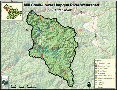
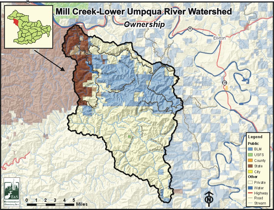
The most common land use in the Mill Creek watershed is forestry, accounting for 86% of the watershed. Agriculture constitutes only about 2% of the land use, and occurs primarily on the floodplains of Lake Creek. The majority of the watershed is privately owned (61%). Public lands account for the remaining 39%, of which 10% is the Elliott State Forest, and 29% is managed by the Bureau of Land Management. Private lands are concentrated in the southern half of the watershed, along Camp Creek, and south of Loon Lake. State lands (the Elliott State Forest) are mostly confined to the northwestern portion of the watershed, and federal lands lie to the east.
There are no population centers within the Mill Creek watershed having census data. Most residents of the watershed live in Ash Valley. Highway 38, which runs east-west, paralleling the Umpqua River, crosses Mill Creek at the confluence with the Umpqua River. The only road of any size within the watershed is Loon Lake Road.

E&S Environmental Chemistry
View large image
|
View as PDF
Current Conditions
The Mill Creek Watershed is home to many fish species including four salmonids. In addition to salmon and trout, many warm water fish, including largemouth bass, white crappie, and bluegill reside in the watershed. The anadromous fish species in the Mill Creek watershed with annual runs are coho, winter steelhead, fall chinook, and Pacific lamprey. The landslide-dam at Loon Lake blocks upstream fish passage, so there are no anadromous fish in the Lake Creek system. However, cutthroat trout are found in the upper reaches of the watershed. Some of the tributary streams, especially Camp Creek, provide spawning habitat for coho, while Mill Creek provides important coho rearing and migration habitat. Spawning and rearing habitat for winter steelhead is found in the lower portion of Mill Creek, and associated tributaries including Camp Creek, Sock Creek, and Footlog Creek. Within the Mill Creek Watershed, the only known spawning and rearing habitat for chinook salmon is found along Mill Creek from the confluence with Sock Creek to the mouth, and in Camp Creek.
The primary water quality concern in the Mill Creek watershed is water temperature. Soup Creek and the lower 0.7 miles of Buck Creek are listed for temperature exceedence on the Oregon Department of Environmental Quality's 303(d) list of water quality-limited streams. Camp Creek, Lake Creek, Mill Creek, and Otter Creek are listed as water quality limited due to habitat modification, and Otter Creek is also listed for flow modification. The Oregon Department of Fish and Wildlife Fish (ODFW) data identifies six culverts that are known barriers to salmonids in the watershed.
The upland portions of the watershed are mainly forested with coniferous, Douglas-fir stands. Coniferous forests cover 80% of the watershed, 12% of which are trees larger than 30 inches diameter at breast height (DBH). Hardwood forests comprise 6% of the watershed, and are most common along stream corridors and in some of the lower-elevation areas. Of the 23 ODFW surveyed stream reaches, the only reach that exhibited good riparian conditions was Sock Creek. Large woody debris conditions were primarily poor, including all of the Mill Creek sites and most of the Camp Creek sites
Compiled by Jay Walters, private consultant, Barnes and Associates (2006)


