 INSTITUTE FOR NATURAL RESOURCES
Oregon Explorer Top Menu
You are here
Watersheds
Landscapes and Ecosystems
Myrtle Creek Watershed
Key Statistics
| Size (acres) | 76,322 |
| Percent Public Ownership | 41 |
| Miles of anadromous salmonid streams | 108 |
| Highest elevation (feet) | 4,486 |
| Lowest elevation (feet) | 572 |
Location and Size
The Myrtle Creek fifth-field watershed is located in the south-central portion of the Umpqua Basin just east of Interstate Five. The watershed is 76,322 acres and stretches a maximum of 11 miles north to south and 17 miles east to west. Myrtle Creek is a tributary of the South Umpqua River.
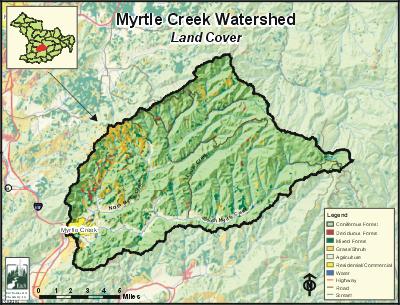
E&S Environmental Chemistry
View large image
|
View as PDF
Landscape and Features
Although less than one stream mile in length, Myrtle Creek is locally considered the mainstem stream in the watershed. North Myrtle Creek (18 stream miles) and South Myrtle Creek (22 stream miles) are tributaries to Myrtle Creek.
Most of the watershed is fairly steep with stream channels dissecting the landscape. The lowest point in the watershed is 572 feet where Myrtle Creek meets the South Umpqua River in the southwest, and the highest point is 4,486 feet at Deadman Mountain on the southeastern border of the Cascades. For most of the watershed, elevation ranges from 700 to 1,000 feet. North and South Myrtle creeks both have narrow floodplains, generally less than a quarter mile in width; as these streams converge to form Myrtle Creek, the floodplain valley become broader.
Approximately 83% of the City of Myrtle Creek is within the Myrtle Creek Watershed. Most of the population in the watershed lives within the City of Myrtle Creek and in the valley bottoms along North and South Myrtle creeks and their major tributaries. North Myrtle Road and South Myrtle Road provide access to the eastern portion of the watershed.
The most common land use in the Myrtle Creek Watershed is forestry, with over 79% of the land base used for public or private forestry. Agriculture constitutes 18%, and mostly occurs near the City of Myrtle Creek and within the South Myrtle Creek Valley. Land ownership is primarily private (57%), with public ownership mostly administered by the Bureau of Land Management.
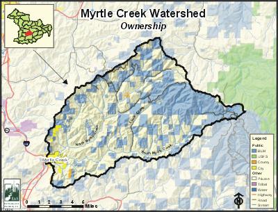
E&S Environmental Chemistry
View large image
|
View as PDF
Current Conditions
In the Myrtle Creek Watershed, coho, winter steelhead, and cutthroat trout are the only salmonids with resident populations or annual runs. Although spring and fall chinook have been documented in Myrtle Creek, North Myrtle Creek, and South Myrtle Creek, their presence is intermittent and does not constitute a run. Warm water fish, including largemouth bass, smallmouth bass, yellow perch, bluegill, brown bullhead, and pumpkinseed, have also been reported in the watershed. These fish are most likely introduced to streams through private ponds, or migrate into the watershed from the South Umpqua River.
Myrtle Creek, North Myrtle Creek, South Myrtle Creek, and the lower reaches of many larger tributaries have riparian areas that are mostly thin strips of hardwoods interspersed with shrubs and blackberries. The upper reaches of North and South Myrtle creeks and their tributaries are mostly conifer forests; these areas correspond with lands used for public and private forestry. Oregon Department of Fish and Wildlife (ODFW) stream habitat surveys conducted in 1994 suggest that poor riffles and poor levels of large woody debris limit salmonid habitat in Myrtle Creek, North Myrtle Creek, South Myrtle Creek, and many of the tributaries.
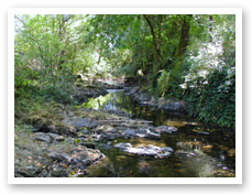
Photo courtesy of Partnership
for the Umpqua Rivers
In the Myrtle Creek Watershed, portions of North and South Myrtle creeks and seven of their tributaries are on the Oregon Department of Environmental Quality (ODEQ) 303(d) list for violating stream temperature standards. North and South Myrtle creeks are also considered water quality limited for flow modification, and North Myrtle Creek is water quality limited for habitat modification. In the ODEQ 303(d) list, Myrtle Creek is considered part of North Myrtle Creek and not a separate stream. Therefore, Myrtle Creek is also 303(d) listed for temperature and considered water quality limited for habitat and flow modification.
In 2002, most of Myrtle Creek was 303(d) listed for ammonia. The cause of the high ammonia values was effluent discharged from the Myrtle Creek and Tri-City wastewater treatment plant during times of low stream flow. In 2003, the wastewater treatment plant was extensively renovated and is now in compliance with ODEQ water quality standards. The Roseburg office of the ODEQ believes Myrtle Creek can be removed from the 303(d) list for ammonia toxicity.
Specific UBWC Enhancement Opportunities for the Myrtle Creek Watershed
1. Actively seek out opportunities with landowners, businesses, and resident groups in key areas to enlist participation in the following restoration projects and activities:
-
Improve irrigation efficiency and encouraging instream water leasing on main stem Myrtle Creek, North Myrtle Creek, South Myrtle Creek, and tributaries with irrigation rights, including Bilger Creek, Frozen Creek, and Louis Creek.
-
Develop projects on the following streams:
-
Big Lick Creek - monitor for fish presence.
-
Bilger Creek - instream enhancement (all) and riparian fencing/stock water, tree planting, and blackberry conversion (headwaters and mouth).
-
Buck Fork Creek - instream enhancement (all).
-
Cedar Hollow - monitor for fish presence.
-
Frozen Creek - riparian fencing/stock water, tree planting, and blackberry conversion (lower two-thirds).
-
Harrison Young Brook - monitor for fish presence.
-
Lally Creek - monitor for fish presence.
-
Lees Creek - instream enhancement (all).
-
Long Wiley Creek - monitor for fish presence (also on Short Wiley Creek).
-
Louis Creek - instream enhancement (upper two-thirds), riparian fencing/stock water, tree planting, and blackberry conversion (lower half). Also monitor for fish presence on upper reaches.
-
North Myrtle Creek - instream enhancement (upper reaches), riparian fencing/stock water, tree planting, and blackberry conversion (between Lees Creek and Buck Fork Creek and between Frozen Creek and Slide Creek).
-
School Hollow Creek - riparian fencing/stock water, tree planting, and blackberry conversion (all). Also monitor for fish presence.
-
Slide Creek - instream enhancement (all), riparian fencing/stock water, tree planting, and blackberry conversion (lower half).
-
South Myrtle Creek - instream enhancement (upper reaches).
-
Weaver Creek - instream enhancement (all).
-
2. Work with interested landowners on a case-by-case basis on the following project types:
-
Improve instream fish habitat in areas with good riparian zones and an active channel that is less than 30 feet.
-
Enhance and/or protect riparian zones and wetlands to improve wildlife habitat, fish habitat, and water quality conditions.
3. Develop educational materials and/or outreach programs to educate target audiences about fish habitat and water quality-related issues:
-
Create educational brochures about bank erosion, the problems associated with channel modification, and the importance of riparian areas. These could be given to new landowners through real estate agents.
-
Develop public service announcements about ways of improving or maintaining riparian and instream conditions, such as the benefits of riparian fencing and how to use fertilizers and pesticides in a stream-friendly fashion.
-
Design engaging displays about fish passage barriers for community events, such as the Douglas County Fair.
-
Give presentations at citizen groups about the benefits to landowners and to fish that result from upland stock water systems, off-channel shade trees, and instream water leasing.
4. Support local fish habitat and water quality research:
-
Train volunteers to conduct fish and water quality monitoring and research.
-
Provide equipment necessary for local water quality research.
-
Survey long-term landowners and residents about historical and current fish distribution and abundance.
-
Encourage school and student participation in monitoring and research.
5. Enlist landowner participation to remove other fish passage barriers as identified. Work with landowners to eliminate barriers to fish passage at the following locations:
-
Bilger Creek: Two sites located approximately at Bilger Creek Road mile 2.0 and mile 2.5.
-
Frozen Creek: Two sites, the first at the Frozen Creek - North Myrtle Creek Road crossing and the second at Frozen Creek Road mile 0.75.
-
Lees Creek: Two sites located approximately at Lees Creek Road mile 0.25 and at the Lees Creek - BLM road 28.4-21crossing.
-
Weaver Creek: One site located approximately at Weaver Creek Road mile 0.5. 6. Educate policy makers about the obstacles preventing greater landowner participation in voluntary fish habitat and water quality improvement methods.
Sources
Geyer, Nancy A. Myrtle Creek Watershed Assessment and Action Plan. Roseburg, Oregon: Prepared for the Umpqua Basin Watershed Council; 2003 June.


