 INSTITUTE FOR NATURAL RESOURCES
Oregon Explorer Top Menu
You are here
Watersheds
Landscapes and Ecosystems
Olalla Creek-Lookingglass Creek Watershed
Key Statistics
| Size (acres) | 103,001 |
| Percent Public Ownership | 27 |
| Miles of anadromous salmonid streams | 166 |
| Highest elevation (feet) | 3,492 |
| Lowest elevation (feet) | 483 |
Location and Size
Located along the western boarder of the Umpqua Basin, the Olalla-Lookingglass fifth-field watershed is 103,001 acres. The watershed is a maximum of 20 miles north to south and 13 miles east to west. Lookingglass Creek flows into the South Umpqua River just southwest of the City of Winston.
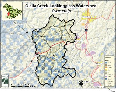
E&S Environmental
View large image
|
View as PDF
Landscape and Features
There are three major streams within the Olalla-Lookingglass Watershed. Lookingglass Creek is 11 miles long and is considered the main stem stream of this watershed. Olalla Creek is a tributary of Lookingglass Creek and is 22 miles long. Tenmile Creek is a major tributary to Olalla Creek and is 12 miles in length. The Olalla-Lookingglass Watershed is home to one of Douglas County's major dams. Berry Creek Dam, which forms Ben Irving Reservoir, is located near the confluence of Berry Creek and Olalla Creek.
The Olalla-Lookingglass Watershed exhibits varied relief. Lookingglass Valley is a particularly large expanse of a broad and very gently rolling plain that contrasts with the more steep topography of the rest of the watershed. The southern portion of the watershed is a moderately steep landscape with incised streams. The watershed's highest point is 3,492 feet on top of Nickel Mountain in the southeast and the lowest point is 483 feet at the mouth of Lookingglass Creek.
There are no incorporated cities within the Olalla/Lookingglass Watershed. Rural residential areas within the watershed include Lookingglass, Tenmile, Olalla, and Reston. Highway 42 is the largest road and runs roughly east to west through the middle of the watershed.
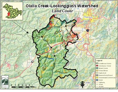
The most common land use in the Olalla/Lookingglass Watershed is forestry (76%). Agricultural areas account for 19% of the watershed's land base and are concentrated in Lookingglass Valley, near the City of Winston, and along Tenmile Creek and Olalla Creek. Land ownership is mostly private (72%), with public ownership (27%) administered primarily by the Bureau of Land Management.
E&S Environmental Chemistry
View large image
|
View as PDF
Current Conditions
Many of the larger streams within the Olalla-Lookingglass Watershed provide habitat for winter steelhead, coho, and cutthroat trout. Fall chinook spawn in Lookingglass Creek to the confluence with Olalla Creek. The watershed has established populations of brown bullhead, and bluegill have been documented in Lookingglass Creek.
Although forestry is the dominant land use in the Olalla-Lookingglass Watershed, hardwood stands constitute more of the watershed's riparian areas than do conifer forests. In the watershed's valleys, riparian areas are usually thin strips of hardwoods intermixed with rangeland, grass, shrubs, and blackberries. Oregon Department of Fish and Wildlife (ODFW) stream habitat surveys conducted in 1995 and 1996 suggest that low levels of large woody debris and poor riffles limit salmonid habitat in this watershed.
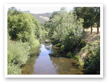
Photo courtesy of Partnership
for the Umpqua Rivers
In the Olalla-Lookingglass Watershed, stream temperatures have resulted in Oregon Department of Environmental Quality (ODEQ) 303(d) listings for Thompson Creek and Olalla Creek. Olalla Creek is also 303(d) listed for biological criteria and considered water quality impaired for flow modification. Thompson Creek is considered impaired for flow modification and habitat modification.
Berry Creek Dam was constructed between 1978 and 1980 primarily to provide water for irrigation and municipal uses and to enhance stream conditions. At a height of 130 feet with no fish ladder, the dam is a complete barrier to fish. Before construction, it was believed that Berry Creek did not have fish runs. However, local residents recall steelhead populations in Berry Creek above the dam site prior to construction. Non-native fish such as largemouth bass reside within Ben Irving Reservoir, and there are resident populations of cutthroat trout and other native fish above Berry Creek Dam. Ben Irving Reservoir provides year-round water releases into the Olalla Creek system.
Specific UBWC Enhancement Opportunities for the Olalla-Lookingglass Watershed
1. Actively seek out opportunities with landowners, businesses, and resident groups in key areas to enlist participation in the following restoration projects and activities:
-
Improve irrigation efficiency and encourage instream water leasing on Lookingglass Creek, Olalla Creek, Morgan Creek, and Tenmile Creek.
-
Develop projects on the following streams:
-
Applegate Creek - plant riparian areas, monitor high nutrient loads (lower half), encourage WQ monitoring underway by Wildlife Safari (no anadromous fish above Heart Lake).
-
Archambeau Creek - fence and plant riparian areas, inventory barriers, provide educational opportunities on management of stock (especially horse) wastes.
-
Bear Creek - research erosion and sediment load issues (no anadromous fish).
-
Berry Creek - research erosion and sediment load issues (no anadromous fish above dam).
-
Berry Creek Reservoir - research effect of turbidity on fish, provide educational opportunities on the cause/effect of turbidity (no anadromous fish).
-
Bushnell Creek - enhance stream with woody debris, inventory barriers, work with community group on culvert replacements.
-
Byron Creek - enhance stream with woody debris, fence and plant riparian areas (lower half), monitor impact of past instream projects.
-
Byron Creek, North & East forks - enhance stream with woody debris, inventory barriers.
-
Coarse Gold Creek - enhance stream with woody debris, monitor water quality at mouth, inventory barriers, determine fish presence (BLM and RFP owned).
-
Flournoy Creek - fence and plant riparian areas, promote off-channel stock management, convert blackberry to riparian vegetation (lower half).
-
Larson Creek - determine fish presence, fence and plant riparian areas, inventory barriers, restore natural meander of creek.
-
Little Muley Creek - enhance stream with woody debris, inventory barriers.
-
Lookingglass Creek - fence and plant riparian areas, promote off-channel stock management, convert blackberry to riparian vegetation, establish erosion control measures, provide educational opportunities on stock management.
-
Lookingglass Creek, unnamed tributary at northernmost bend - determine fish presence, inventory barriers and channel modification, fence and plant riparian areas, monitor water quality.
-
McNabb Creek - fence and plant riparian areas, convert blackberry to riparian vegetation (lower half), promote off-channel stock management, inventory barriers.
-
Morgan Creek - fence and plant riparian areas, convert blackberry to riparian vegetation (lower half), promote off-channel stock management.
-
Muns Creek - determine fish presence (upper half).
-
Olalla Creek - fence and plant riparian areas, promote off-channel stock management, inventory barriers, convert blackberry to riparian vegetation (lower half), enhance stream with woody debris (upper half).
-
Perron Creek - fence and plant riparian areas, promote off-channel stock management, convert blackberry to riparian vegetation (no anadromous fish, wheelchair accessible pond for fishing).
-
Porter Creek - inventory barriers, fence and plant riparian areas, promote off-channel stock management, convert blackberry to riparian vegetation (lower quarter), enhance stream with woody debris (upper three-quarters).
-
Rock Creek - enhance stream with woody debris, inventory barriers, fence and plant riparian areas (include tributaries with planting).
-
Shields Creek - fence and plant riparian areas, promote off-channel stock management, inventory barriers, convert blackberry to riparian vegetation (lower half), enhance stream with woody debris (upper half).
-
Strickland Canyon unnamed tributary (3&4) - fence and plant riparian area (lower third), inventory barriers.
-
Suicide Creek - partner with youth groups on projects and education events (portion owned by Boy Scouts of America), inventory barriers, determine fish presence, monitor BLM culvert replacement project (upper half).
-
Tenmile Creek - determine fish presence, inventory barriers, fence and plant riparian area, promote off-channel stock management, establish erosion control measures, convert blackberry to riparian vegetation (lower half), enhance stream with woody debris (upper half).
-
Thompson Creek - promote as a significant and unique watershed, protect traditional wetland areas, plant riparian areas with conifers, enhance stream with woody debris, inventory barriers (natural barrier with isolated fish population in upper half).
-
Wildcat Creek - inventory barriers. Willingham Creek - inventory barriers.
-
2. Work with interested landowners on a case-by-case basis on the following project types:
-
Improve instream fish habitat in areas with good riparian zones and an active channel that is less than 30 feet; and
-
Enhance and/or protect riparian zones and wetlands to improve wildlife habitat, fish habitat, and water quality conditions; and
-
Conduct landowner interviews and write a comprehensive historical account of the Olalla-Lookingglass Watershed.
3. Develop educational materials and/or outreach programs to educate target audiences about fish habitat and water quality-related issues:
-
Create educational brochures about bank erosion, the problems associated with channel modification, and the importance of riparian areas. These could be given to new landowners through real estate agents.
-
Provide educational materials at Ben Irving Reservoir explaining the causes of turbidity in water.
-
Create an educational outreach program targeted at livestock owners to encourage management of stock waste.
-
Develop public service announcements about ways of improving or maintaining riparian and instream conditions, such as the benefits of riparian fencing and how to use fertilizers and pesticides in a stream-friendly fashion.
-
Design engaging displays about fish passage barriers for community events, such as the Douglas County Fair.
-
Promote the benefits of wetlands through outreach.
-
Give presentations at citizen groups about the benefits to landowners and to fish that result from upland stock water systems, off-channel shade trees, and instream water leasing.
4. Support local fish habitat and water quality research:
-
Train volunteers to conduct fish and water quality monitoring and research.
-
Provide equipment necessary for local water quality research.
-
Continue water temperature studies and attempt to correlate temperature to fish presence.
-
Inventory fish passage barriers and presence/absence in all streams.
-
Survey long-term landowners and residents about historical and current fish distribution and abundance.
-
Encourage school and student participation in monitoring and research. 5. Enlist landowner participation to remove other fish passage barriers as identified. Work with landowners to eliminate barriers to fish passage at the following locations:
-
Lee's culvert on Archambeau (west side of Flournoy Valley).
-
Bushnell Creek culvert identified by community group.
-
Culvert on Upper Tenmile tributary after F. Fork.
-
Strickland Canyon unnamed tributary - two possible culvert obstacles.
-
Sources
DeVore, Matt B. and Geyer, Nancy A. Olalla / Lookingglass Watershed Assessment and Action Plan . Roseburg, Oregon: Prepared for the Umpqua Basin Watershed Council; 2003 July.


