 INSTITUTE FOR NATURAL RESOURCES
Oregon Explorer Top Menu
You are here
Watersheds
Landscapes and Ecosystems
Rock Creek-North Umpqua River Watershed
Key Statistics
| Size (acres) | 62,655 |
| Percent Public Ownership | 45 |
| Miles of anadromous salmonid streams | 57 |
| Highest elevation (feet) | 4,730 |
| Lowest elevation (feet) | 808 |
Location and Size
The Rock Creek - North Umpqua River fifth-field watershed (referred to as the Rock Creek Watershed) is located in the northeastern portion of the Umpqua Basin. It is composed of 62,655 acres and includes 19.9 miles of Rock Creek. The watershed stretches a maximum of 14 miles north to south, and 13 miles east to west.
E&S Environmental Chemistry
View large image
|
View as PDF
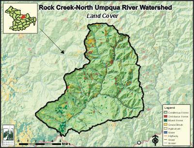
Landscape and Features
The Rock Creek Watershed has fairly consistent high relief topography, with about nine percent on exceptionally steep slopes. The elevation ranges from 4,730 feet at Huckleberry Mountain on the northern edge of the watershed near the headwaters of Northeast Fork Rock Creek, to 808 feet near the mouth of Rock Creek. Other high-elevation areas include Old Fairview and Mace Mountain located on the ridge separating the Rock Creek and Middle North Umpqua watersheds. The area is characterized by a high density of streams that deeply dissect the landscape. The largest floodplains occur along Rock Creek several miles up from its confluence with the North Umpqua River.
The nearest population center is the unincorporated community of Idleyld Park located just west of the region. Glide is a larger unincorporated town located three miles further west. Some residents of Idleyld Park live within the Rock Creek Watershed along the lower reaches of Rock Creek. The Rock Creek Road (county road 78) branches north from Highway 138 near the mouth of Rock Creek and continues along the main channel turning into BLM Road 26-3-1.
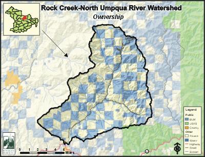
The most common land use in the region is forestry, with well over half of the land base used for public or private forestry. Most of the remaining land is forest land in Federal Reserve areas where there is no commercial timber harvest. Most of the Federal Reserve areas are located in a checkerboard pattern in the northeast third of the watershed. Additional reserves on federal land exist throughout the watershed along streams that have been buffered from commercial timber harvest. Farm, residential, and empty rural lands make up less than one percent of the area. Land ownership is split between private (approximately 54%) and public (45%). Private land ownership is dominated by industrial timber land owners while the majority of public land is managed by the Bureau of Land Management. Small private landowners and the State of Oregon own or manage approximately 1% of the watershed located near the lower reaches of Rock Creek.
E&S Environmental Chemistry
View large image
|
View as PDF
Current Conditions
The watershed provides habitat for summer and winter steelhead, searun and resident cutthroat trout, coho, and spring Chinook salmon. The North Umpqua River also supports rainbow trout, lamprey, sculpin, dace, shiners, pikeminnows, and largescale suckers that may occasionally be found in the lower reaches of Rock Creek.
The Rock Creek Watershed has 57 stream miles of anadromous salmonid habitat. The Rock Creek Hatchery, located along the lower portion of Rock Creek produces spring Chinook, coho, and summer steelhead that are released into the North Umpqua River. Hatchery management practices have evolved over time to minimize effects on wild populations. It is likely that early operations had some effects on wild stocks in Rock Creek and the North Umpqua River. A diversion dam on Rock Creek for the hatchery is a barrier to fish primarily during low flows. A new fish ladder design is underway with plans to rebuild the site so it is passable to fish. There are 23 known man-made barriers to fish within the watershed. Of these, 12 are barriers to juvenile fish only. Most of these are the result of failing or ineffective culverts on roads.
Since this region is primarily used for forestry, it is not surprising that most streams in the watershed have conifer forest-dominated riparian areas. However, many of the streambank areas along the floodplains have large amounts of red alder and cottonwood trees. These species are more common where the soil has been highly disturbed by historic logging practices and active stream channel flooding and erosion. Early harvested riparian areas (prior to 1972) removed trees to the streambank along many of the major streams. Harvest since then has required no harvest buffers of various sizes along many streams, including all fish-bearing streams. Road construction began in the 1940s and 1950s when many of the main roads were built following close to stream channels removing riparian vegetation. Road density is also high in the watershed. ODFW stream habitat surveys suggest that many of the riparian areas surveyed are in poor condition and that the channels are also lacking large wood pieces necessary for fish habitat.
Precipitation in the region is high with an average of over 63 inches per year measured at Idleyld Park, just outside the western boundary. Well over half of the area is within the transient snow zone. These areas are prone to rain-on-snow events that can dramatically increase stream flows in a short period of time, causing substantial flooding and scouring of streambeds and surrounding vegetation. In 1964, Rock Creek experienced a 100-year flood event from a rain-on-snow storm that caused substantial scouring of riparian vegetation and streambed material such as gravel and large wood, moving and depositing it further downstream. Peak flow events commonly trigger landslides including debris flows that radically alter habitat in streams. A debris flow extending over three miles in Harrington Creek, a long tributary to Rock Creek, was triggered following large storms in 1996. Peak flows also eliminate winter habitat for young salmonids, flushing them downstream, thus reducing the salmon population in many areas.
As is common in southwestern Oregon, stream temperature limits water quality in many of the streams throughout the watershed. Four streams in the Rock Creek Watershed are on the 2002 ODEQ 303(d) list for stream temperature: East Fork Rock Creek, Harrington Creek, Miller Creek, and Rock Creek. The warmest sections measured are on Rock Creek just above East Fork Rock Creek. The Rock Creek hatchery pumps water up from the North Umpqua River during summer low flow periods in part to provide cooler water to hatchery fish. Increased temperatures are attributed to increases in disease and poorer health for salmonids. Numerous other streams also have warm temperatures that could limit salmonid rearing in these reaches.
Sources
Winn, Lisa A. Rock Creek Region Assessment and Action Plan. Roseburg, Oregon: Prepared for the Umpqua Basin Watershed Council and Roseburg Bureau of Land Management; 2006 June.


