 INSTITUTE FOR NATURAL RESOURCES
Oregon Explorer Top Menu
You are here
Watersheds
Umpqua River-Sawyer Rapids Watershed
Key Statistics
| Size (acres) | 63,505 |
| Percent public ownership | 33 |
| Miles of anadromous salmonid streams | 79 |
| Highest elevation (feet) | 1,890 |
| Lowest elevation (feet) | 8 |
Location and Size
The Umpqua River-Sawyer Rapids fifth-field watershed--more commonly called the Middle Umpqua River Watershed--is located in the western portion of the Umpqua Basin. The watershed is approximately 63,505 acres, stretching a maximum of 9 miles north to south and 17 miles east to west. The Middle Umpqua River Watershed is the area that drains into the Umpqua River for 24 river miles between the confluence of Elk Creek and the confluence of Mill Creek, just below Scottsburg.
E&S Environmental Chemistry
View large image
|
View as PDF
Landscape and Features
Elevations in the Middle Umpqua River Watershed range from 8 feet above sea level at the western edge of the watershed to 1,890 feet in the eastern portion of the watershed. The watershed drains a varied landscape, from steep-sloped, highly-dissected headwaters to low-gradient broad floodplains. Most of the watershed is dominated by land that is less than 34% in gradient. East of the confluence with Sawyer Creek the Umpqua valley broadens considerably.
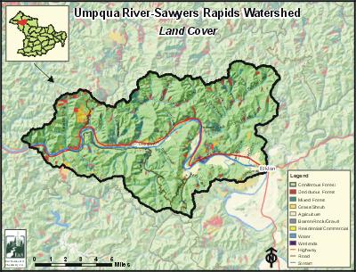
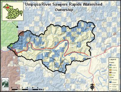
The most common land use in the Middle Umpqua River Watershed is forestry, accounting for more than three-quarters (78%) of the watershed. Agriculture constitutes about 8% of the land use, occurring in the floodplains of the Umpqua River in the eastern third of the watershed, near Elkton. Privately-owned lands account for 64% of the watershed, while 34% is publicly-owned. Public ownership is almost completely administered by the Bureau of Land Management (BLM). Waterways make up the remaining 2% of the land.
The communities of Elkton, Scottsburg, and Wells Creek are the only population centers within the Middle Umpqua River Watershed. There are many farms and ranches in the vicinity, so the population in the watershed is substantially larger than Elkton alone. Highway 38 runs east-west across the watershed, paralleling the Umpqua River.
E&S Environmental Chemistry
View large image
|
View as PDF
Current Conditions
The Middle Umpqua River watershed is home to many fish species, including four salmonids. In addition to salmon and trout, many warm water fish, including largemouth bass, yellow perch, and bluegill, reside in the watershed. There are about 79 stream miles of anadromous salmonid streams within the Middle Umpqua River Watershed. Winter steelhead and coho each use more than half of the potential available habitat. Summer steelhead, spring chinook, and fall chinook use 1ess than one third. Spawning and rearing habitat for chinook salmon is found along the lower reaches of Weatherly, Paradise, Lutsinger, Sawyer, and Hurd Creeks. Summer steelhead are not known to spawn in the Middle Umpqua River watershed, but migrate to spawning areas further upstream in the Umpqua Basin. Resident cutthroat are generally limited to small tributaries above the ranges of anadromous fish. According to Oregon Department of Fish and Wildlife (ODFW) data regarding fish passage barriers, there is one dam and 12 culverts that may hinder passage of juvenile or adult salmon.
The length of the Umpqua River in this watershed was placed on the Oregon 303(d) water quality-limited list due to documented violations of water quality standards. The most important water quality concerns in the watershed are fecal coliform bacteria and water temperature. Paradise Creek, Little Paradise Creek, Weatherly Creek, and Lutsinger Creek are considered to be water quality limited due to habitat modification, and the Umpqua River is water quality limited due to flow modification.
In the upland portions of the Middle Umpqua River Watershed coniferous forest stands, particularly Douglas-fir, are predominant. More than one-third of the coniferous forests within the watershed are comprised of trees larger than 20 inches diameter at breast height (DBH). Hardwood forests account for 9% of the watershed, and are more common along stream corridors. Riparian conditions were rated by ODFW surveys as mostly fair (82% of surveyed reaches). Large woody debris conditions were poor in 59% of the surveyed reaches.
Compiled by Jay Walters, private consultant, Barnes and Associates (2006)


