 INSTITUTE FOR NATURAL RESOURCES
Oregon Explorer Top Menu
You are here
Watersheds
Upper Cow Creek Watershed
Key Statistics
| Size (acres) | 47,483 |
| Percent Public Ownership | 67 |
| Miles of anadromous salmonid streams | 0 |
| Highest elevation (feet) | 5,095 |
| Lowest elevation (feet) | 1,780 |
Location and Size
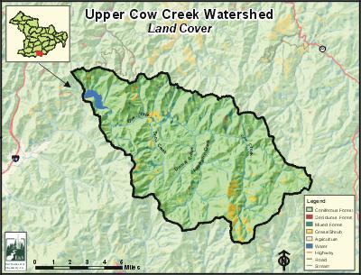
The Upper Cow Creek fifth-field watershed is located along the south-central border of the Umpqua Basin. This watershed is 47,483 acres and is among the basin's smallest fifth-field watersheds. Upper Cow Creek is a maximum of eight miles from north to south and 10 miles from east to west. The watershed includes 20 miles of Cow Creek from its headwaters to Galesville Dam.
E&S Environmental Chemistry
View large image
|
View as PDF
Landscape and Features
The Upper Cow Creek Watershed exhibits fairly steep topography with streams dissecting the landscape. The lowest point in the watershed is 1,780 feet, which is the elevation at the top of the Galesville Dam spillway. The highest point is Cedar Springs Mountain at 5,095 feet. In the Upper Cow Creek Watershed, about 96% of the land base is above 2,000 feet. Although the floodplain of Upper Cow Creek is not very large, it does open up at "The Meadows" where Snow Creek feeds into Cow Creek.
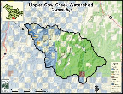
Almost 99% of the Upper Cow Creek Watershed is used for public or private forestry and the landscape is dominated by Douglas-fir forests. Most of the remaining one percent of the land is used for agricultural and residential homes; these are scattered along the Cow Creek floodplain. In Upper Cow Creek, 67% of the land base is managed by the federal government, primarily by the US Forest Service.
Data from the 2000 census indicate that the population for the entire watershed is no more than 311 people. There are no incorporated cities in Upper Cow Creek. There is an active community center located near the junction of the watershed's two main roads: Upper Cow Creek Road and Snow Creek Road.
Completed in October of 1986, Galesville Dam is the largest dam in the Umpqua Basin. The dam is 167 feet from the streambed to the dam's spillway. Galesville Reservoir has a storage capacity of 42,225 acre feet. The primary functions of Galesville Dam and Galesville Reservoir are as follows: 1) Regulate water for downstream irrigation, industrial uses, and municipal uses; 2) regulate and release stream flow for fish and other aquatic life; 3) provide flood control; 4) generate hydroelectric power; and 5) provide recreational opportunities.
E&S Environmental Chemistry
View large image
|
View as PDF
Current Conditions
Galesville Dam completely blocks all anadromous salmonids from entering the Upper Cow Creek Watershed. Above the reservoir, Upper Cow Creek's streams provide habitat for cutthroat trout and other resident native fish such as sculpin and dace. Warm water fish, including largemouth bass smallmouth bass, yellow perch, bluegill, and brown bullhead, have reproducing populations within the reservoir. These fish were introduced to the reservoir for recreational fishing.
In 1996, the Oregon Department of Fish and Wildlife (ODFW) surveyed stream conditions for about one-third of potential fish-bearing streams in the Upper Cow Creek Watershed. Although riparian habitat conditions are generally good in this watershed, it appears that low levels of large woody debris and poor riffles are limiting cutthroat habitat.
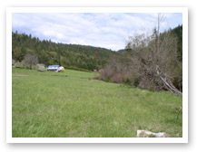
Photo courtesy of Partnership
for the Umpqua Rivers
Four streams within the Upper Cow Creek watershed are on the Oregon Department of Environmental Quality (ODEQ) 303(d) list for temperature: Applegate Creek, Cow Creek, Dismal Creek, and Snow Creek. Applegate Creek and Dismal Creek are also designated water quality limited for habitat modification, and Cow Creek is water quality limited for habitat modification and flow modification.
Galesville Reservoir is on the ODEQ 303(d) list for mercury contamination. Galesville Reservoir was listed for mercury in 2002 because of elevated methlymercury levels in the meat of fish caught from the reservoir. It appears that natural mercury found in soils and rocks around Galesville Reservoir is the source of the contamination. Methymercury in fish meat cannot be removed or reduced through any cleaning, cooking, or preservation methods; therefore, the Oregon Department of Health and Human Services recommends that people limit their consumption of fish from Galesville Reservoir because of health concerns. Mercury levels in the water are not high enough to pose a risk to people swimming or boating in the reservoir.
Specific UBWC Enhancement Opportunities for the Upper Cow Creek Watershed
UBWC staff members believe that within the Upper Cow Creek Watershed, East Fork Cow Creek is generally in the best condition. Mainstem Cow Creek, French Creek, Applegate Creek, Snow Creek, and Meadow Creek have the greatest potential for fish habitat and water quality improvement projects. Since the Upper Cow Creek Watershed has no anadromous fish due to Galesville Dam, the watershed is a low priority for UBWC stream restoration projects. Listed below are some watershed enhancement opportunities within the Upper Cow Creek Watershed. These recommendations are based on the assessment findings as well as the professional experience of UBWC, DSWCD, and ODFW staff members.
1. Work with interested landowners on a case-by-case basis to on the following project types:
- Improve instream fish habitat in areas with good riparian zones and an active channel that is less than 30 feet; and
- Enhance and/or protect riparian zones and wetlands to improve wildlife habitat, fish habitat, and water quality conditions. In this watershed, planting streamside willows and trees has been very successful.
- Create or improve wetlands.
2. Develop educational materials and/or outreach programs to educate target audiences about fish habitat and water quality-related issues:
- Create educational brochures about bank erosion, the problems associated with channel modification, and the importance of riparian areas. These could be given to new landowners through real estate agents.
- Distribute information to landowners about ways of improving or maintaining riparian and instream conditions, such as the benefits of riparian fencing and how to use fertilizers and pesticides in a stream-friendly fashion.
- Give presentations at citizen groups about the benefits to landowners and to fish that result from upland stock water systems, off-channel shade trees, and instream water leasing.
- Continue to educate landowners about mercury contamination in Galesville Reservoir.
3. Support local fish habitat and water quality research:
- Train volunteers to conduct fish and water quality monitoring and research.
- Provide equipment necessary for local water quality research and monitoring.
- Survey long-term landowners and residents about historical and current fish distribution and abundance.
- Encourage school and student participation in monitoring and research.
4. Enlist landowner participation to remove fish passage barriers as identified.
5. Educate policy makers about the obstacles preventing greater landowner participation in voluntary fish habitat and water quality improvement methods.
Sources
Geyer, Nancy A. West Fork Cow Creek Watershed Assessment and Action Plan. Roseburg, Oregon: Prepared for the Umpqua Basin Watershed Council; 2003 November.


