 INSTITUTE FOR NATURAL RESOURCES
Oregon Explorer Top Menu
You are here
Umpqua
Upper Umpqua River Watershed
Key Statistics
| Size (acres) | 169,676 |
| Percent Public Ownership | 34 |
| Miles of anadromous salmonid streams | 216 |
| Highest elevation (feet) | 2,854 |
| Lowest elevation (feet) | 75 |
Location and Size
The Upper Umpqua River fifth-field watershed is located in the west central portion of the Umpqua Basin. The watershed is approximately 169,676 acres, stretching a maximum of 27 miles north to south and 12 miles east to west. The Upper Umpqua River watershed begins at the confluence of the North and South Umpqua Rivers ("river forks") and extends downstream to the confluence with Elk Creek at Elkton. It includes 62 river miles of the Umpqua River.
E&S Environmental Chemistry
View large image
|
View as PDF
Landscape and Features
Elevations in the Upper Umpqua River watershed range from 75 feet above sea level to 2,854 feet in the western portion of the watershed. The watershed drains a varied landscape, from steep-sloped, highly-dissected headwaters to low-gradient broad floodplains. The Upper Umpqua River and the lowermost sections of Wolf Creek and Mill Creek have significant floodplains. The floodplain of the Upper Umpqua River broadens considerably in both the northern and the southern portions of the watershed.
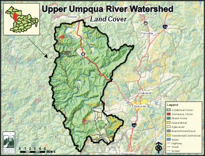
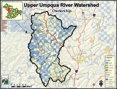
The most common land use in the Upper Umpqua River watershed is forestry, accounting for about 70% of the watershed. Agriculture constitutes about 16% of the land use, and mostly occurs in the floodplains of the Umpqua River and its tributary streams Mill Creek and Rock Creek. The remaining 14% of the watershed is utilized for a variety of miscellaneous land uses, including rural residential and rock quarries. Land ownership is approximately two-thirds private (65%) and one-third public (35%) public. The Bureau of Land Management administers nearly all of the public land. Private and BLM-administered lands are generally distributed in an alternating "checkerboard" pattern. Most land adjacent to the Umpqua River is private.
Kellogg, Tyee, Millwood, Umpqua, and Cleveland are the only population centers within the watershed. However, census data was available only for the community of Umpqua. Highway 138 (the Elkton-Sutherlin Highway) runs north-south, paralleling the Umpqua River in the northern part of the watershed. It is a major connecting route between the Umpqua Valley and the coast.
E&S Environmental Chemistry
View large image
|
View as PDF
Current Conditions
The Upper Umpqua River watershed is home to many fish species, including four salmonids. In addition to salmon and trout, many warm water fish, including largemouth bass, yellow perch, and bluegill reside in the watershed. There are about 240 stream miles of potential anadromous salmonid habitat within the Upper Umpqua River watershed. The anadromous fish species in the Upper Umpqua River watershed with annual runs are coho, winter and summer steelhead, spring and fall chinook, sea run cutthroat, and Pacific lamprey. Winter steelhead and coho each use more than two-thirds of the potential available habitat. Summer steelhead, spring chinook, and fall chinook use 26% or less. Resident cutthroat are generally limited to small tributaries above the ranges of anadromous fish.
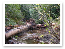
Photo courtesy of Partnership
for the Umpqua Rivers
The entire length of the Umpqua River, as well as five tributary streams, were placed on the Oregon Department of Environmental Quality's 303(d) list of water quality-limited streams. The most important water quality concerns in the watershed are fecal coliform bacteria and water temperature. Oregon Department of Fish and Wildlife (ODFW) data lists two dams and 24 culverts in the Upper Umpqua River watershed that are obstacles to adult or juvenile fish passage. Additionally, a study published in 2002 by the BLM identifies 32 culverts restricting access to habitat anadromous fish species on their lands.
The upland portions of the watershed coniferous forest stands, particularly Douglas-fir, are predominant. Coniferous forests cover 66% of the watershed, 29% of which are trees larger than 20 inches diameter at breast height (DBH). Hardwood forests account for only 3% of the watershed, and are more common along stream corridors and in some of the lower-elevation areas. Of the 115 ODFW surveyed stream reaches in the Upper Umpqua River watershed, about half were rated as poor for large woody debris conditions. In most tributary systems, riparian conditions were mostly commonly rated as fair.
Compiled by Jay Walters, private consultant, Barnes and Associates (2006)
Umpqua


