 INSTITUTE FOR NATURAL RESOURCES
Oregon Explorer Top Menu
You are here
Middle Columbia-Hood
Middle Columbia-Hood
LOADING...

Please be patient.
-
Tall bridge across Columbia River at Hood River. Mt. Hood, Hood River, and Hood River Valley on far side of river
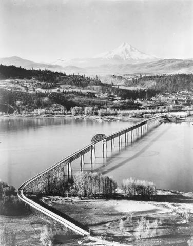
A black and white view of the toll bridge built across the Columbia River to link Hood River, Oregon, with the vicinity of Bingen, Washington. Built in the 1920s. This view is looking south towards Hood River...
-
Hood River Basin Master Plan for Angler Access and Associated Recreational Uses 1968
Abstract -- Hood River, located in the north central part of the State, heads on the
-
Abundance, Life History, and Distribution of Bull Trout in the Hood River Basin: A Summary of Findings from 2006 to 2009...
Abstract -- Bull trout have been adversely affected by many land, water, and fisheries management activities
-
Hood River Bull Trout Abundance, Life History, and Habitat Connectivity, 2007 Progress Reports 2007
Abstract -- Hood River bull trout are thought to exist as two independent reproductive units (USFWS
-
Sedimentologic changes in the deposits of an evolving lahar-flood in 2006, Hood River Basin, Mount Hood, Oregon
Over a span of six days from November 2nd -- 7th, 2006 approximately 43 cm of precipitation fell over the Hood River Basin in Oregon. A lahar was initiated on the Eliot Branch of the Middle Fork Hood River by...
-
Cascade Rapids before the Bonneville Dam was built
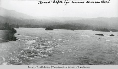
A black and white view that has been identified as Cascade Rapids on the Columbia River, seen before the Bonneville Dam was built. In the foreground are low white-capped waves; to the right a low, tree-lined...
-
Cascade Rapids before the Bonneville Dam was built

A black and white view that has been identified as Cascade Rapids on the Columbia River, seen before the Bonneville Dam was built. In the foreground are low white-capped waves; to the right a low, tree-lined...
-
Bridge of the Gods, Columbia River, On line of O. R. & N. Co.

A colored postcard view of the Columbia River. In the top right-hand corner in red the text reads "Bridge of the Gods, Columbia River. On line of O. R. & N. Co." In the foreground of the picture is a rocky...
-
Bridge of the Gods, Columbia River, On line of O. R. & N. Co.

A colored postcard view of the Columbia River. In the top right-hand corner in red the text reads "Bridge of the Gods, Columbia River. On line of O. R. & N. Co." In the foreground of the picture is a rocky...
Pages


