 INSTITUTE FOR NATURAL RESOURCES
Oregon Explorer Top Menu
You are here
South Santiam
South Santiam
LOADING...

Please be patient.
-
South Santiam River Creel Survey, 2003
Abstract -- South Santiam River Creel Survey - 2003. Sample information and pressure, first draft.
-
South Santiam River Creel Survey - 2002
Abstract -- South Santiam River Creel Survey - 2002. Sample information and pressure, first draft.
-
South Santiam Watershed Assessment
Abstract -- The South Santiam River drains approximately 1,040 square miles and is a primary tributary
-
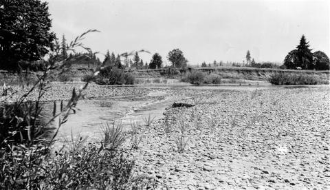
South Santiam River

South Santiam River, Oregon Cutaway bank is found below the confluence with Crabtree Creek;1940-08-03
-
Canyon Creek Ranch covered bridge

Canyon Creek Ranch covered bridge is a 75 foot modified queenpost covered bridge built in c1932 by Gale S. Hill, spanning the South Santiam River, and located 1 1/2 miles east of Cascadia near the South Santiam...
-
169-O38 Foster covered bridge (Foster, South Santiam River)

Foster bridge, 1 mile north of Foster, Oregon, over South Santiam River, is a 240 foot Howe covered bridge built in 1940. Location: T13S R1E S27
-
South Santiam River

South Santiam River above the mouth of Mark's Slough showing how very little water gets by the lower wooden dam where the Albany power ditch arises The white streak in the background is the sewage from Mark's...
-
South Santiam River

South Santiam River channel above Lebanon, Oregon Large rubble and bedrock is becoming dominant; 1940-08-12 From Album 1 page 8
-
South Santiam River
South Santiam River, Oregon Good C1 riffle 1600 yards above confluence with Crabtree Creek;1940-08-04
-
South Santiam riffle

Riffle on the South Santiam River about 2 1/2 miles below Crabtree Bridge All stones were heavily coated with brownish-green slime and persistent foam piled up in backwaters and floated down the river;Paper...
Pages


