 INSTITUTE FOR NATURAL RESOURCES
Oregon Explorer Top Menu
You are here
Gales Creek
Gales Creek
LOADING...

Please be patient.
-
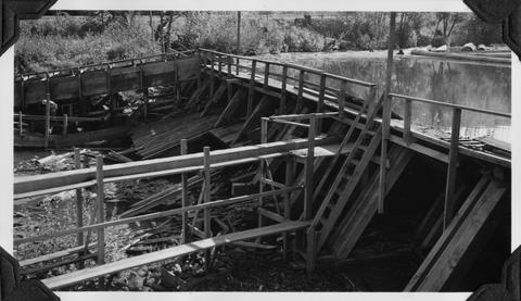
Dam and fishway
-
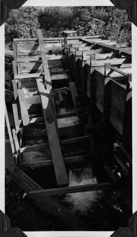
Fish ladder
-
Landslide inventory maps of the Gales Creek quadrangle, Washington County, Oregon

plate 1. Landslide inventory map of the northwest quarter of the Gales Creek quadrangle, Washington County, Oregon -- plate 2. Landslide inventory map of the northeast quarter of the Gales Creek quadrangle,...
-
Geology, structure, and tectonic history of the Tualatin Basin, northwestern Oregon
The northwest-trending Neogene Tualatin basin in northwestern Oregon is a pull-apart
-
Highway sign

Sign near the new WPA highway being constructed from Glenwood to Tillamook, Oregon; 1940-09-21 From Album 1 page 40
-
Gales Creek Trail

This archived document is maintained by the Oregon State Library as part of the Oregon Documents Depository Program. It is for informational purposes and may not be suitable for legal purposes.
-
Gales Creek Trail

This archived document is maintained by the Oregon State Library as part of the Oregon Documents Depository Program. It is for informational purposes and may not be suitable for legal purposes.
-
Gales Creek Trail

This archived document is maintained by the Oregon State Library as part of the Oregon Documents Depository Program. It is for informational purposes and may not be suitable for legal purposes.
-
I. Direction of maximum horizontal compression in western Oregon determined by borehole breakouts. II. Structure and...
Elliptical borehole enlargements or "breakouts" caused by systematic spalling of a
-
ODOT city quadrangle maps

Portland area quad maps: Dixie Mountain, Sauvie Island, Gales Creek, Forest Grove, Hillsboro, Linnton, Portland, Mount Tabor, Camas, Washougal, Gaston, Laurelwood, Scholls, Beaverton, Lake Oswego, Gladstone,...
Pages


