 INSTITUTE FOR NATURAL RESOURCES
Oregon Explorer Top Menu
You are here
Soils
Soils
Landscapes and Ecosystems
LOADING...

Please be patient.
-
Aspicilia aspera
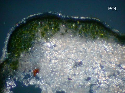
Thallus section POL; Habitat: Salt desert shrub with shallow silty loam soils; Location: Orchard Training Area, 50 km S of Boise, S of Bigfoot Butte; Substrate: Soil; Elevation: 951 meters; Notes: DNA...
-
Aspicilia aspera

Thallus section; Habitat: Salt desert shrub with shallow silty loam soils; Location: Orchard Training Area, 50 km S of Boise, S of Bigfoot Butte; Substrate: Soil; Elevation: 951 meters; Notes: DNA extracted,...
-
Aspicilia aspera

Habit; Habitat: Salt desert shrub with shallow silty loam soils; Location: Orchard Training Area, 50 km S of Boise, S of Bigfoot Butte; Substrate: Soil; Elevation: 951 meters; Notes: DNA extracted, ITS, nuLSU....
-
Aspicilia aspera

Habit; Habitat: Salt desert shrub with shallow silty loam soils; Location: Orchard Training Area, 50 km S of Boise, S of Bigfoot Butte; Substrate: Soil; Elevation: 951 meters; Notes: DNA extracted, ITS, nuLSU....
-
Multimodel Simulations of Forest Harvesting Effects on Long-Term Productivity and CN Cycling in Aspen Forests
The effects of forest management on soil carbon (C) and nitrogen (N) dynamics vary by harvest type and species. We simulated long-term effects of bole-only harvesting of aspen (Populus tremuloides) on stand...
-
Use of Water Indices Derived from Landsat OLI Imagery and GIS to Estimate the Hydrologic Connectivity of Wetlands in the...
This study compared two remote sensing water indices: the Normalized Difference Water Index (NDWI) and the Modified NDWI (MNDWI). Both indices were calculated using publically-available data from the Landsat 8...
-
OHA assessment of health risk from exposure to soils around Bullseye Glass

This archived document is maintained by the Oregon State Library as part of the Oregon Documents Depository Program. It is for informational purposes and may not be suitable for legal purposes.
-
Uroboros Glass area-wide soil sampling and analysis plan

This archived document is maintained by the Oregon State Library as part of the Oregon Documents Depository Program. It is for informational purposes and may not be suitable for legal purposes.
-
The West Tidewater Earthflow, Northern Oregon Coast Range
The West Tidewater earthflow, one of the largest in Oregon's history, occurred in December of 1994. The earthflow is located approximately 15 km north of Jewel, Oregon near the summit ofthe Northern Oregon...
-
Slope Failure Detection through Multi-temporal Lidar Data and Geotechnical Soils Analysis of the Deep-Seated Madrone...
Landslide hazard assessment of densely forested, remote, and difficult to access areas can be rapidly accomplished with airborne light detection and ranging (lidar) data. An evaluation of geomorphic change by...
Pages


