 INSTITUTE FOR NATURAL RESOURCES
Oregon Explorer Top Menu
You are here
Sage-Grouse
Landscapes and Ecosystems
Threat Based Ecostate Map
OverviewThreat-based ecostate maps provide a spatial depiction of rangeland condition across public and private land in eastern Oregon and across the sagebrush biome. These maps are based on the principles of Threat-Based Land Management (Johnson et al 2019) as a framework to identify and address the primary large scale, ecosystem-level threats to sagebrush ecosystems in the northern Great Basin, and are widely used by the SageCon Partnership. Rangeland condition is described by ecological states (ecostates) that express current vegetation composition and level of threat from invasive annual grasses, wildfire, and juniper encroachment based on the cover of key rangeland functional groups and the severity of threats present. Change over time is captured from circa 1990 to present, with the intention to update maps each year. NOTE: Version 4 of the ecostate maps, including 2023 data and an updated and improved rule set, are currently in production. Download links below have been disabled until the new dataset is available, but the current ecostate map for 2021-2023 across the sagebrush biome is available for viewing and download in the SageCon Landscape Planning Tool. |
Check out our brand new Threat-Based Ecostate Mapping Storymap!
|
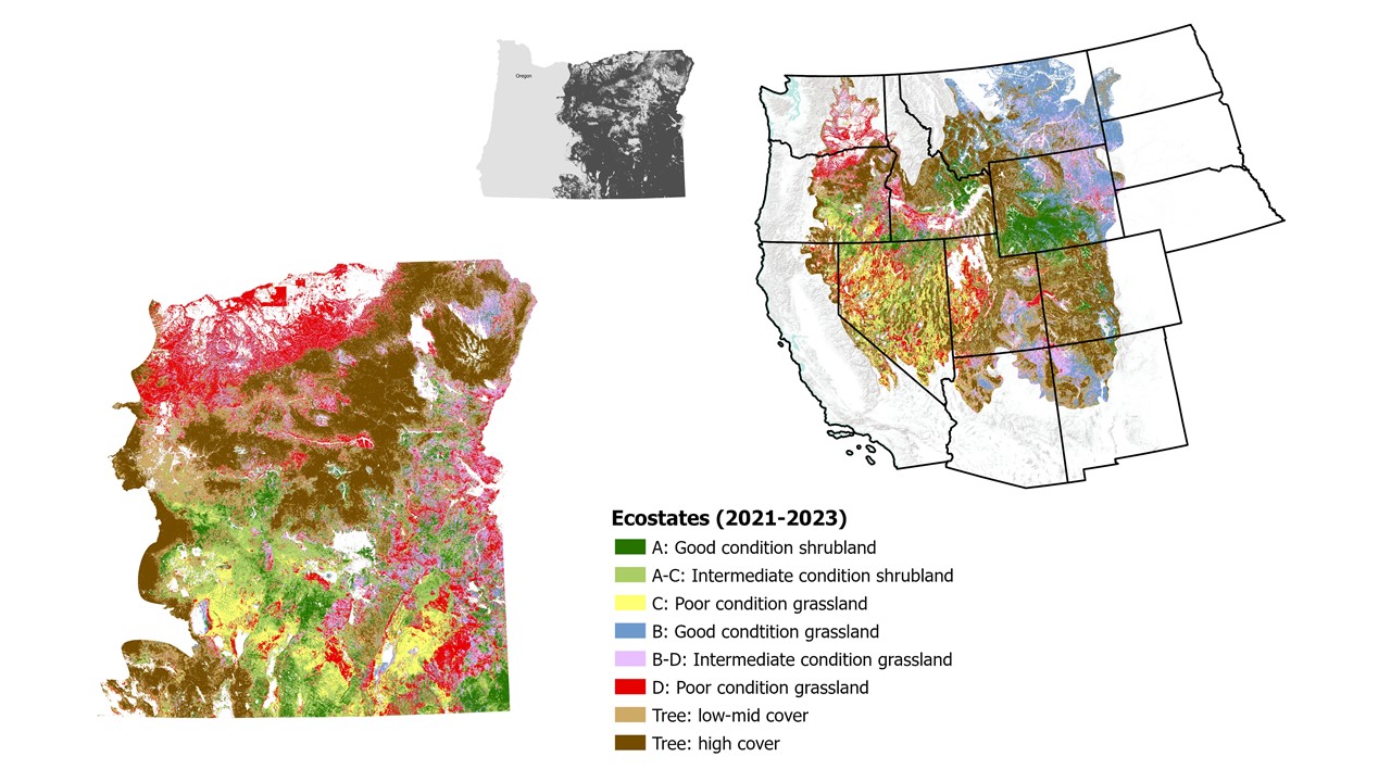
Ecostate Time Series maps (version 4) consists of a set of 32 maps representing 3-year averages from 1989-1991 to 2021-2023 (the most current time step available as of spring 2024). These maps can be used as a recent snapshot of ecosystem condition, with planned annual updates over time, and also allow us to track trends over time. Because they represent 3-year time slices, these maps are not appropriate for detecting year-to-year changes, but are intended to capture landscape-level change on medium to long time frames, such as depicting long-term trends or evaluating post-fire recovery or treatment effectiveness over >5-10 years. Check out the ecostate summarization tool within the SageCon Landscape Planning Tool to explore status and trends of ecostates in a user-defined area within eastern Oregon. Soon the ecostate summarization tool will be available across the sagebrush biome - stay tuned! However, rememebr that these maps were originally developed for sagebrush rangelands in Oregon and have since expanded to the sagebrush biome; use caution outside of the northern Great Basin and avoid applying this model in areas that are not current or historic sagebrush steppe.

Technical documentation
Updated technical documentation will be available soon.
Data access
- The most recent ecostate map (and many other data layers) can be viewed, summarized and downloaded from the SageCon Landscape Planning Tool. The ecostate summarization tool within the Landscape Planning Tool allows users to summarize ecostates for a customized area of interest and time frame.
- The full time series of ecostate maps can be downloaded directly. Stay tuned for updated download links, as well as georeferenced PDFs for counties in Oregon to use ecostate maps in the field.
Technical resources
For more rangeland technical resources, see our Rangeland Assessment and Management Tools resource page.
Contact Dylan O'Leary (dylan.oleary@oregonstate.edu) or Megan Creutzburg (megan.creutzburg@oregonstate.edu) with any questions or for technical support.
Sponsored by


