 INSTITUTE FOR NATURAL RESOURCES
Oregon Explorer Top Menu
You are here
Hood River
Hood River
LOADING...

Please be patient.
-
View looking west from Angel's Rest.

View looking west from Angel's Rest. Bridal Veil on Columbia River in foreground. In the foreground is a tree-covered sloping hillside leading down to the river. The river bends to the right and there is a dock...
-
View looking west from Angel's Rest.

View looking west from Angel's Rest. Bridal Veil on Columbia River in foreground. In the foreground is a tree-covered sloping hillside leading down to the river. The river bends to the right and there is a dock...
-
Bonneville Dam: 1939 Aerial Photographs

3 aerial photographs and a guide map of the Bonneville Dam area taken in 1939 as part of the OCSW river survey.
-
Bridge of the Gods, Columbia River, On line of O. R. & N. Co.

A colored postcard view of the Columbia River. In the top right-hand corner in red the text reads "Bridge of the Gods, Columbia River. On line of O. R. & N. Co." In the foreground of the picture is a rocky...
-
Bridge of the Gods, Columbia River, On line of O. R. & N. Co.

A colored postcard view of the Columbia River. In the top right-hand corner in red the text reads "Bridge of the Gods, Columbia River. On line of O. R. & N. Co." In the foreground of the picture is a rocky...
-
Hassalo being taken over the Cascade Rapids by Capt. J.W. Troup

A dramatic black and white view of a stern wheeler identified as the "Hassalo" being taken over the Cascade Rapids by Captain J. W. Troup. The boat steams through whitecaps, plumes of smoke trailing from its...
-
Hassalo being taken over the Cascade Rapids by Capt. J.W. Troup

A dramatic black and white view of a stern wheeler identified as the "Hassalo" being taken over the Cascade Rapids by Captain J. W. Troup. The boat steams through whitecaps, plumes of smoke trailing from its...
-
Bridge of the Gods Bridge across Columbia River near Cascade Locks, Or.
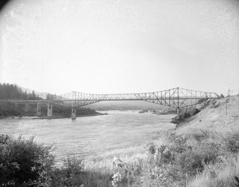
Black and white photograph of the Bridge of the Gods over the Columbia River. Fir trees are visible on the left bank and shrubs and grass are visible on the right bank. Some utility poles are visible on the...
-
Bridge of the Gods Bridge across Columbia River near Cascade Locks, Or.

Black and white photograph of the Bridge of the Gods over the Columbia River. Fir trees are visible on the left bank and shrubs and grass are visible on the right bank. Some utility poles are visible on the...
-
Columbia River; a comprehensive report on the development of the water resources of the Columbia River Basin for irrigation,...

399 p. Prepared by the U. S. Bureau of Reclamation, this document outlines a plan for the use of water and other physical resources of the Columbia River Basin. Presented in the report are descriptions of the...
Pages


