
The Mitigation Planning Map Viewer is a tool for exploring the suitability of potential sites to provide compensatory mitigation. The information made available in the tool will help facilitate a watershed approach to aquatic mitigation using data that describes watershed characteristics, processes, and strategic areas. Additional information about mitigation planning can be viewed on the Department of State Lands website.
A COLLABORATION OF: OSU LIBRARIES & PRESS  INSTITUTE FOR NATURAL RESOURCES
INSTITUTE FOR NATURAL RESOURCESOregon Explorer Top Menu
You are here
Aquatic Mitigation
Aquatic Mitigation
Aquatic Mitigation

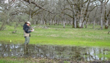
Aquatic mitigation seeks to balance alterations made to our aquatic resources with protecting functions such as controlling floodwater, filtering pollution and providing natural habitats for plants and animals.
The U.S. Army Corps of Engineers and the Oregon Department of State Lands collaboratively but independently administer a permit process to protect, conserve and provide for the best use of many of Oregon’s aquatic resources. This process documents how a proposed project has reduced adverse effects to aquatic resources, and how any unavoidable impacts have been offset by actions, called compensatory mitigation, to replace the area, functions and values of the loss.
EXPLORE RELATED:
The Oregon Rapid Wetland Assessment Protocol (ORWAP) allows a rapid assessment of the functions and values of wetlands. The ORWAP tool provides site-specific mapping and reporting information needed to answer a subset of ORWAP indicator questions. The primary ORWAP documents are provided below under “Explorer Related”. These documents plus the Supplemental Information (Excel spreadsheet) and PDFs of field data forms can be downloaded from the Department of State Lands website.
EXPLORE RELATED:
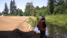
The Stream Function Assessment Method allows a rapid assessment of the functions and values of streams. The SFAM tool provides site-specific mapping and reporting information needed to answer a subset of SFAM indicator questions. The SFAM method and supporting documents are provided below under “Explorer Related or can be downloaded from the Department of State Lands website.
EXPLORE RELATED:
Articles & Stories

Wetland and riparian habitats are found in the following places.
Westside or Coastal and Western...

In Oregon, wetlands are regulated through the authority of a handful of federal and state laws and...
Maps and Tools

"A blueprint for conservation of the state’s native fish and wildlife and their habitats, the...
moreData Collections
About This Topic
Development of the Aquatic Mitigation topic page and content is a collaboration led by the Oregon Department of State Lands, the U.S. Army Corps of Engineers Portland District, and the U.S. Environmental Protection Agency Region 10 with assistance from the Institute of Natural Resources. Funding for this work has been provided by the U.S. Environmental Protection Agency’s Wetland Program Development Grants.


