 INSTITUTE FOR NATURAL RESOURCES
Oregon Explorer Top Menu
You are here
Coastal Hazards
Coastal Hazards
Coast, Ocean, and Marine
LOADING...

Please be patient.
-
Chronic geologic hazard map of the Beverly Beach area, Coastal Lincoln County, Oregon

This archived document is maintained by the Oregon State Library as part of the Oregon Documents Depository Program. It is for informational purposes and may not be suitable for legal purposes.
-
Model coastal erosion overlay zone : to be used in conjunction with DOGAMI coastal hazard risk zone maps and analyses

This archived document is maintained by the Oregon State Library as part of the Oregon Documents Depository Program. It is for informational purposes and may not be suitable for legal purposes.
-
Contents of geotechnical reports related to the impacts of coastal erosion and related hazards: report to the Oregon...

This archived document is maintained by the Oregon State Library as part of the Oregon Documents Depository Program. It is for informational purposes and may not be suitable for legal purposes.
-
Chronic geologic hazard maps of coastal Lincoln County, Oregon

[pl. 1] Chronic geologic hazard map of the Salmon River area, coastal Lincoln County, Oregon (O-94-12) -- [pl. 2] ... Roads End area (O-94-13) -- [pl. 3] ... Lincoln City - Wecoma Beach area (O-94-14) -- [pl....
-
Relative earthquake hazard maps of the Siletz Bay area, coastal Lincoln County, Oregon

Map 1. Liquefaction susceptibility map of the Siletz Bay area, coastal Lincoln County, Oregon -- Map 2. Amplification susceptibility map of the Siletz Bay area, coastal Lincoln County, Oregon -- Map 3....
-
Erosion and flood hazard map of the Seal Rock area, Coastal Lincoln County, Oregon

This archived document is maintained by the Oregon State Library as part of the Oregon Documents Depository Program. It is for informational purposes and may not be suitable for legal purposes.
-
Real-time change and damage detection of landslides and other earth movements threatening public infrastructure

This archived document is maintained by the Oregon State Library as part of the Oregon Documents Depository Program. It is for informational purposes and may not be suitable for legal purposes.
-
OSU Wave Research Facility
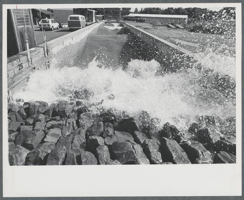
This wave tank, constructed in 1972, was 342 feet long, and served as the genesis for the O.H. Hinsdale Wave Research Laboratory. Research being conducted at the time this photo was taken pertained to oil...
-
Evaluation of coastal erosion hazard zones along dune and bluff backed shorelines in Tillamook County, Oregon: Cascade Head...

This archived document is maintained by the Oregon State Library as part of the Oregon Documents Depository Program. It is for informational purposes and may not be suitable for legal purposes.
-
A Tale of Two Counties: Exploring Co-Produced Coastal Adaptation Strategies in Tillamook County, OR and Grays Harbor County,...
Coastal communities throughout the US West Coast and elsewhere are facing the daunting task of preparing for climate change impacts, particularly the hazards from increased flooding and erosion. With sea-level...
Pages


