 INSTITUTE FOR NATURAL RESOURCES
Oregon Explorer Top Menu
You are here
Hazards
Hazards
LOADING...

Please be patient.
-
Clear Lake Spillway Rehabilitate - Specs. No. 200C-889 –Roy D. Garren Corporation, Contractor
CN-12-201-378NA Klamath Project - Oregon-California. View showing fractured rock where right wall is to be constructed. High point of rock in center of photo had to be taken off due to safety hazard. Also, it...
-
Clear Lake Spillway Rehabilitation - Specs. No. 200C-889 Roy D. Garren Corporation, Contractor
CN-12-201-379KA Klamath Project - Oregon-California. View showing fractured rock where right wall is to be constructed. High point of rock in center of photo had to be taken off due to safety hazard. It would...
-
Environmental Development Plan: Coal Liquefaction
This text is about the development plan of how to address environmental concerns that have to with the process of coal liquefaction. This includes the current technology's description as well as major research...
-
Regulations on Leasing of Geothermal Resources and Drilling for Geothermal Resources in Hawaii
This document contains the many different aspects to consider when dealing with the regulations on leasing geothermal resources and drilling in the state of Hawaii
-
Geological Examination of the Two Old Maps in the Tokugawa Era concerning the "Shimabara Catastrophe", Western Kyushu, Japan
Mayu-yama dacitic lava dome of the Unzen volcanic area in western Kyushu, Japan, suddenly collapsed on May 21. 1792. Approximately 15000 people were killed in the collapse and the tsunami subsequent to the...
-
Proceedings of Workshop XLIV: Geological, Geophysical, and Tectonic Setting of the Cascade Range
The Cascade Range is an active volcanic arc that is formed by the continuing subduction of the Juan de Fuca plate system beneath North America. Understanding of the Cascade Range and its tectonic setting is not...
-
Emergency Relief Administration-sponsored cleanup of fire hazard area
-
Aerial view of flood at Vanport City, Oregon
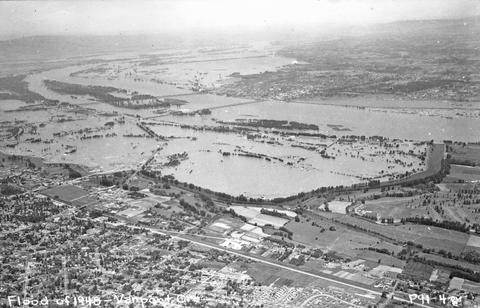
Vanport City was located between the Portland city boundary and the Columbia River. Vanport was destroyed on May 30, 1948 when a section of the dike collapsed during a flood on the Columbia River.
-
Columbus Day windstorm damage
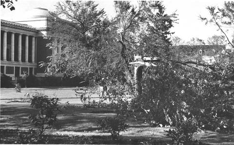
Columbus Day windstorm damage, 1962. On Columbus Day in 1962 (October 12th), a severe windstorm (75 mph sustained winds) moved inland from the Pacific Ocean and caused $50,000 damage to the OSU campus....
-
View of flooded portion of Vanport, Oregon
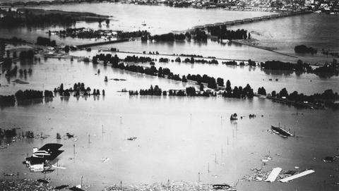
Vanport City was located between the Portland city boundary and the Columbia River. Vanport was destroyed on May 30, 1948 when a section of the dike collapsed during a flood on the Columbia River.
Pages


